ABR’s green lane experts, Mike Beddows and Simon Ewbank head out to ride a collection of great lanes in Warwickshire and Kent
31 – Alcester trails
5 miles | Wow factor ✪✪✪✪✪
This issue’s featured green lanes consist of four short trails that form a route of nearly five miles, including 2.82 miles of unclassified country roads.
They are conveniently located approx. Ten miles south of Birmingham and are all fairly straightforward. The route includes an easy, and a not-so-easy ford (the latter is probably best left to the experts, an explanation for why can be found in the route text).
The trails follow farm access roads and pass through some great scenery where there is evidence of previous off-piste activity on one of the sections. This appears to be 4×4 traffic and has resulted in the access being blocked by strategically placed stakes to guide the traffic in the right direction.
The trails start near the village of Alcester, near Coughton Court, an English Tudor house that is open to the public. I did them after significant rainfall so the trails had plenty of puddles and were pretty slippery.
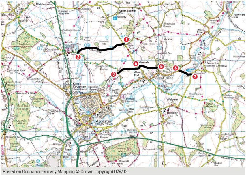
The Route
1-2
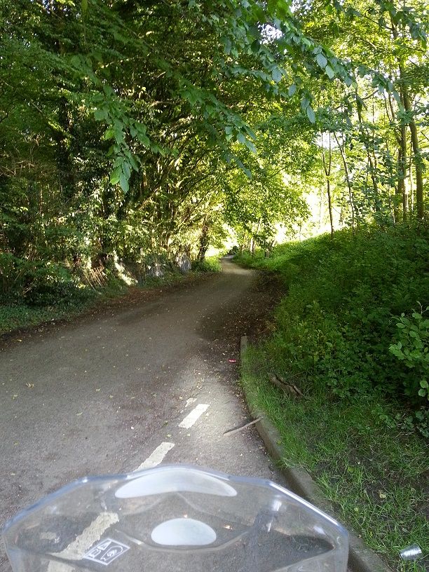
Start at the entry to the unclassified country road from Spernal Way. Follow the Arden Way as it winds its way between farmers fields.
DISTANCE: 5 miles (approx.)
NEAREST TOWN: Alcester (South)
MAPS: These trails span two maps, Birmingham (220) and Stratford (205)
START/END GRID REFERENCE: SP106607 / SP134594
DIFFICULTY RATING: 2 (Great Alne Ford 5+)
WOW FACTOR: 3
OTHER TRAILS: There is a fantastic beginner’s loop south of Warwick that was detailed in issue 14 of adventure Bike rider
—
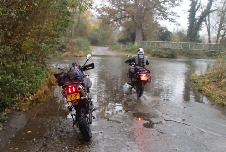
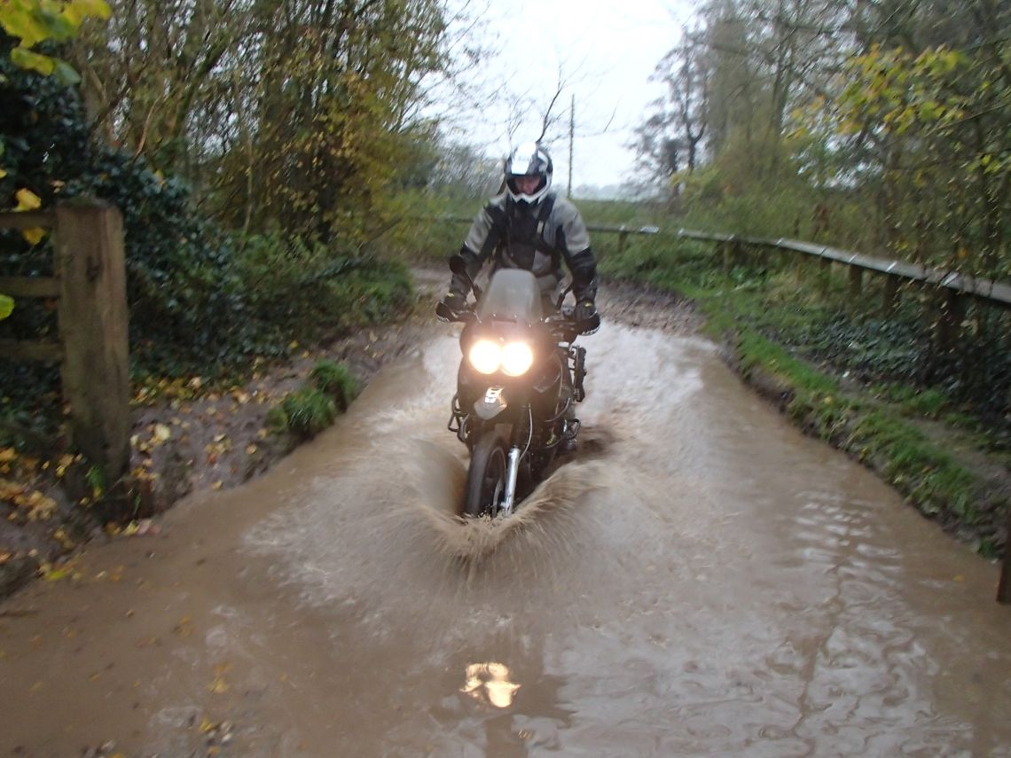
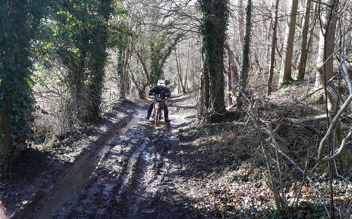
The route starts with a solid base with grass in the middle. The going here is fairly easy and it is a good introduction to trail riding. As you proceed there are more puddles (will be dry hollows when it’s not raining). Towards the end of the lane, the puddles are larger and just before you meet Coughton Fields Lane at the end there is a large knee-deep puddle that spans the trail. You have no choice but to proceed through it.
The route now heads left on a short tarmac section, but take the opportunity to turn right and head through the Coughton ford. The water is fairly shallow with a slippery concrete base so take it steady.
If in doubt, and if the water is flowing fast, feel free to walk over the bridge on the right and observe the river for the best way across, if you’re still in doubt, don’t risk it. Continue to the next trail.
2-3
Ride the short tarmac section to the start of the Stoal lane.
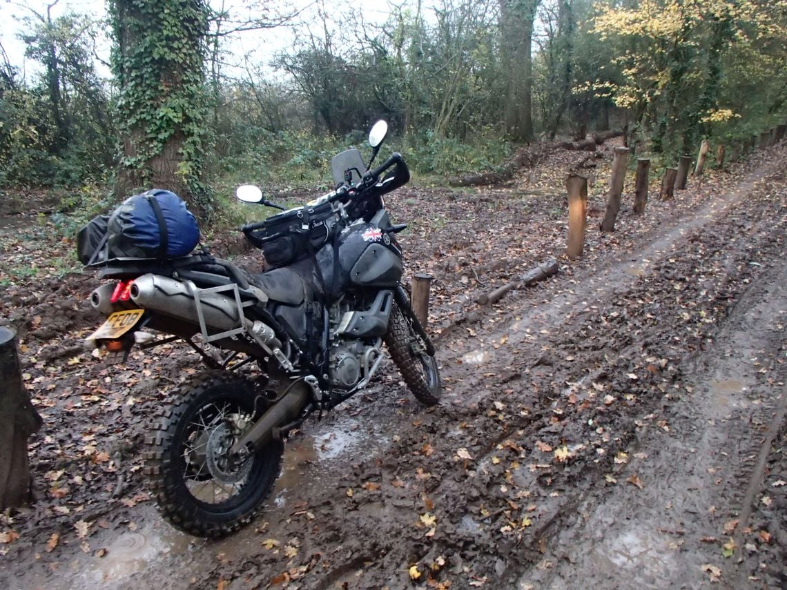
3-4
The trail is on the left and heads up through a wood. Stay on the track. There are wooden stakes stopping 4x4s deviating up the track on the left which is deeply rutted and very muddy.
I do not know if the original route used to head left where the 4×4 tracks are or whether that was actual off-piste action. Regardless, stick to the track.
This section is slippery as you ride over the fallen leaves (I did it in late autumn) so take care. The trail becomes a lot easier once out of the wood and riding on the edges of farmers’ fields. Continue to the road.
4-5
Take a left then immediately right onto the next section of the trail. This section is fairly easy with a hard compact base. Continue to the end of the trail.
5-6
Beginners should end here, or maybe continue to see the ford but do not go through it.
6-7
I have to admit to not doing Great Alne ford (grade 5* ford on www.wetroads.co.uk).
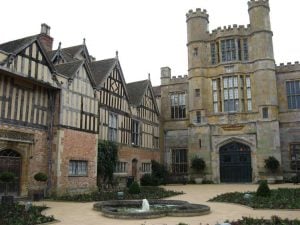
Coughton Court has been the home of the Throckmorton family since 1409. It is an English Tudor country house and is a Grade 1 listed building.
–
The Hall also holds a place in English history for its roles in both the Throckmorton Plot of 1583 to murder Queen Elizabeth 1 of England and the Gunpowder Plot of 1605.
–
The house has been in the ownership of the National Trust since 1946. The family, however, hold a 300-year lease and manage the estate on behalf of the National trust.
–
The house is open to the public all year round and it’s set in extensive grounds with a walled formal garden, a river and a lake.
Time was against me and I did not want to get wet walking through it to find if it is possible or not. When approaching the ford from the Great Alne end you will see a sign saying ‘Ford impassable at ALL times’.
I put a post on ABR asking if this ford was OK to do. Some ABR’s thought it was, others said to stay away.
There is no obvious exit from the start as the ford winds its way upstream for 90 meters to where you can finally escape. Once you start riding upstream you are committed.
There is no turning back. Make sure you are comfortable with the risks first and I suggest you walk the entire length and plan the route (check out Jussi Hyttinen’s river crossing tips from his Siberia ride in Issue 26 of Adventure Bike Rider).
There are no obvious viewing routes from the overgrown banks. I have seen a YouTube clip of Ralph from the ABR forum attempting this on his XT660R only to fall off in the deep section approx ten meters into the ford. I have also seen footage of 4x4s doing this and it does look deep. But, there is internet evidence of bikes successfully navigating it.
Do this ford at your own risk, and please do not do it solo. I for one will be going back on a warmer summer’s day to have a go! (Ed’s note: and if you do it, make sure to write in and let us know!)
32 – A trip around Vigo Village, Kent
6 miles | Wow factor ✪✪✪✪✪
Following on from the Kent byways detailed in issue 26 of Adventure Bike Rider I have pulled together another five that can be tagged onto the end to make a nine byway run.
These are centred around a small village called Vigo which sits on the North Downs. The route starts off at Meopham Green and will take you over six miles, with 4.5 of those being off-road.
The hardest byway carries a wow factor of four and is really only suitable for experienced off-road riders. In the winter all of these trails will require knobblies but in the summer anyone should be able to ride them as long as it is dry.
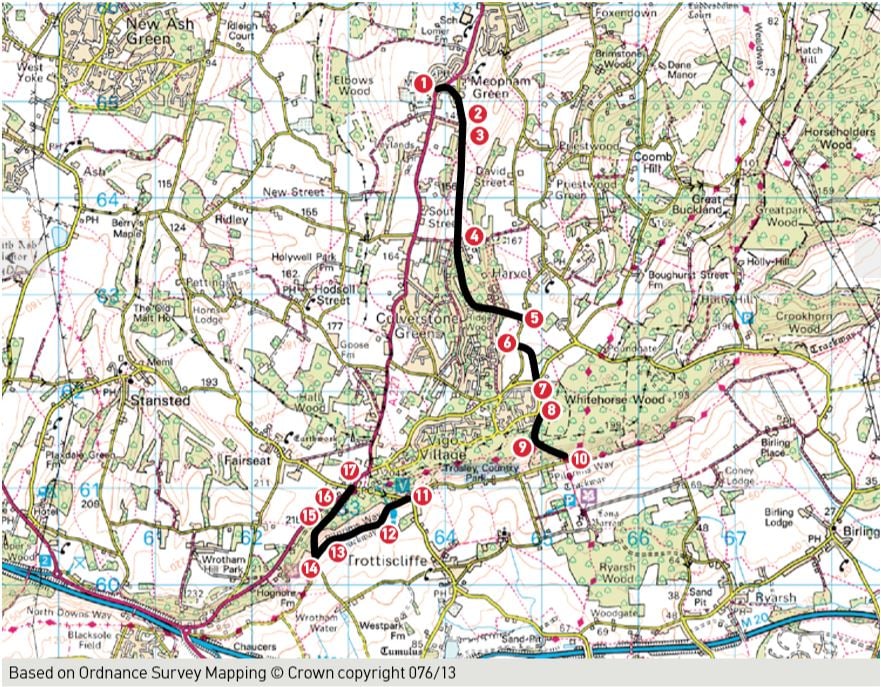
The Route:
Lane one – Meopham Green Byway
1-2
The entrance to the byway is from Steeles Lane and lies directly behind the Meopham Green cricket ground clubhouse. The first section is a wide track with large puddles on either side, beware of local dog walkers here.
2-3
As you approach this next section there will be a large house facing you, take a left just before the house and go down a steep section which forms a large S bend. The trail is made up of loose shingle and chalk, so take care.
DISTANCE: 6 miles total with 4.5 miles of off-road sections
NEAREST TOWN: Vigo Village
START/END GRID REFERENCE: TQ 64132 65020 / TQ 63082 60965
DIFFICULTY RATING: Lane one: 1, Lane two and four: 3, Lane three and five: 4. These are all wet ratings and therefore can drop a rating in the dry.
WOW FACTOR: Lane one: 1, Lane two: 2, Lane three: 4, Lane four: 3, Lane five: 4.
3-4
This mile-long stretch starts off running downhill before it levels out. There are some overhanging shrubs so standing on the pegs is a no-no. It finally ends with another byway crossing it (Heron Hill Lane). Heron Hill Lane is often used, so don’t go flying out onto it.
4-5
Follow Ridge Lane through a small group of houses where caution should be taken. There is a steep climb up and down halfway along this section, with a give way sign in the middle of it (Valley Lane) so be watchful.
5-6
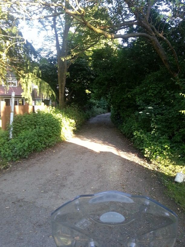
0.2-mile road section to the overgrown entrance of Upper Harvel Byway, take it easy otherwise you’ll miss it.
Lane two – Upper Harvel Byway
6-7
This lane is enclosed by foliage and is more like riding through a tunnel. The track is very deeply rutted and cut up, with tree roots protruding through the ground.
In the winter it is slippery and we have had a few fallers (ABR member V-Stromjohn), being caught out cross-rutting. It is not for beginners and can’t really be ridden fast.
The lane finishes at Harvel Road on a blind bend, so caution is needed when exiting onto the main road.
Lane three – Vigo Steps (Commority Road)
7-8
Very muddy flat section, with puddles and mud everywhere, no real problems but if your bike wasn’t dirty before, it will be now. Even in the summer, this section retains water.
8-9
This starts at a fork in the trail, go left to follow the byway. This is where beginners should stop, turn around and find another route.
This section is enclosed by trees with a steep drop off on the right, there is a barbed-wire fence stopping you from going off the edge but be careful not to bin it because you probably won’t see your bike again.
This section is also very steep and drops 240ft in the space of a tenth of a mile. It is made up of chalk and flint and when it rains becomes a very fast flowing river! Just to make it harder it has about 60 large railway sleepers embedded into it, making steps that run its complete length.
The drop off on these can be up to 12”-14”, so a bash plate and a decent amount of clearance is needed. If you like a challenge on a big bike do this lane. Keep in mind that walkers use the set of steps so caution has to be taken.
Lane four: Trottiscliffe Pilgrims Way Byway
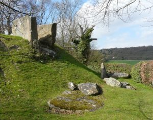
Coldrum Longbarrow (near Trottiscliffe) is the least-damaged megalithic long barrow (a burial tomb from the Neolithic period) in Kent.
–
It is thought that the 3,000-year-old long barrow got its name from the old cornish word ‘Galdrum’ which means ‘place of enchantments’.
–
If you’re riding the Kent byways at dawn on the 1st of may then you’ll be able to see the Hartley Morris men who visit the stones to ‘sing up the sun’ by dancing and singing around the stones.
9-10
The entrance to this lane is halfway up Taylor’s Lane, opposite Pilgrim House. In the summer months this lane is good for beginners but as the rain falls, it becomes more of an intermediate byway and in winter becomes very slippery and a lot harder.
The first section is through Spring Wood on a tree-covered track with fields to the left and steep climbs up the North Downs to the right. The track dips downhill and is rutted, most of it is on an adverse camber which is falling from right to left, so balance is interesting.
10-11
As you exit the woods the trail becomes wider and more undulating and you can get a bit of air at this stage.
Again watch out for walkers. In the winter this section gets pretty slippery.
11-12
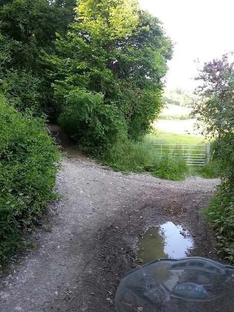
About 100 yards before the end of this trail you will notice that there is another one that forks to the right and goes up the North Downs. This is the Trottiscliffe steps, our next lane.
12-13
Short ride ending on Wrotham Water Lane.
Lane five: Trottiscliffe Steps Byway
Entrance to this lane can either be from the previous byway. Or by turning off at the end of Wrotham Water road, where it meets the Pilgrims way.
12-14
From Wrotham, Water Lane proceed over the speed bump until you come to a fork in the trails. Take the left one to reach Trottiscliffe steps.
14-15
Proceed left onto a wooded section with views on the right across to Wrotham village and Trottiscliffe. In the wet grip is hard to find. This is a tough climb with 6”-8” steps and it is very demanding for big adventure bikes, there are about 40 steps to contend with across its full length. Again this section is not suited to beginners.
15-16
After you have climbed up the steps you now come upon a wider wooded section that flattens off a bit.
16-17
This last section is flat with an intersecting road in between, it’s a long drive to a house and is, therefore, a private no through road. After the drive, the trail becomes rutted as it goes through woods for about 200 yards and finishes at the Gravesend Road (A227). Take care when exiting onto the A227.