

Lawrence Bransby and his son Gareth take a daring diversion after their original route across the Pamir Highway is blocked by a rock slide
After previous trips together to Russia and Morocco, my son, Gareth, and I were looking for something completely different. Central Asia, perhaps?
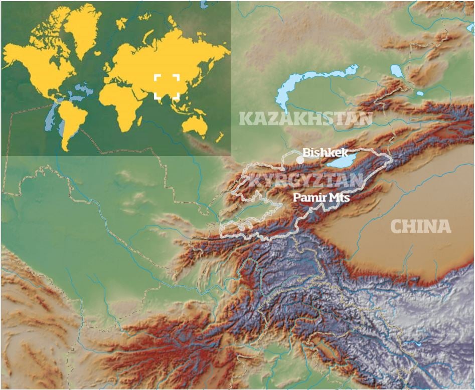
This was the plan: Fly the bikes into Almaty in Kazakhstan, head into the Pamir Mountains and the Pamir Highway, the Silk Road, then press further south through Kyrgyzstan and Tajikistan towards Afghanistan and China.
There were two tracks we were particularly interested in: the first was a dirt road that hugged the Afghan and Chinese borders along the Wakhan Corridor, a thin finger of Afghan territory designed to keep the Russians and British apart during the 19th century; the second was the remote Bartang Pass, described by Lonely Planet as: ’the stark and elemental Bartang Valley, one of the wildest and most beautiful in the western Pamirs… at times the fragile road is only perilously inches between the raging river below and sheer cliff s above.’
We achieved the first but, due to various circumstances, had to give up on the Bartang Pass – so that’s the main destination for our 2015 trip.
Then, after three weeks playing in the mountains, we would ride back to the UK across Kazakhstan, southern Russia and Ukraine. We’d given ourselves five weeks to complete the trip but, when travelling in Central Asia, it’s best not to make too many detailed plans…
The small dotted line
Let’s be blunt here: Kyrgyzstan is not a normal country.
If I hadn’t suggested we stop to gnaw on a gristly sheep’s leg for lunch we would have got over the Taldyk Pass before the landslide blocked the road. But I did.
So we ate our dubious lumps of meat, then pressed on up the pass heading for the beginning of the Pamir Highway and the Afghan border only to find that, just minutes before we got there, half the mountain had collapsed onto the road, blocking our path.
Can’t complain too much, I suppose – we could have been under it. What to do? Our way effectively blocked for the next ten days while they brought in graders to clear the road, we were faced with a six-day detour through the mountains… or attempt a small goat track that Gareth discovered marked on the map as a minute dotted line climbing over the 3,615m Alau Mountain Range.
It was a few hundred kilometres away but better that than travelling halfway across Kyrgyzstan and Tajikistan to get around the rockfall.
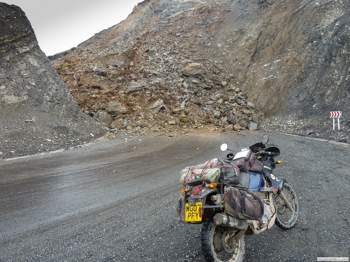
The Rockfall blocking the way
The next day we attempted the pass, knowing, deep down, that there was little chance of our making it – not with loaded bikes and snow covering the upper reaches of the mountains…
At Kyzyl-Kyya we filled up our tanks and one spare fuel container from a bucket scooped out of a 44-gallon drum locked away in a dusty shed.
Gareth looked up from his GPS and informed me, ‘Twenty kilometres and the map runs out…’ No more data.
We would be on our own, halfway up a scary range of mountains, with just a dodgy map and the track.
The sun beat down on us from a sky in which cumulus clouds were just beginning to form. At least it wasn’t going to rain – yet, I thought.
At times, when I could chance taking my eyes off the road, I looked up at the mountains ahead that barred our way and I could count five consecutive ranges, like massive waves in a turbulent sea, each higher and more hazed with blue than the next, the final mountain covered with snow and completely dominating the horizon.
At the first army checkpoint behind a high, gaited fence, our papers were scrutinised by a young soldier with a firearm slung over his shoulder.
The ’office’ was a converted metal container. There was an army 4×4 parked outback; the track ahead still had signs of tyre marks and the soldiers didn’t laugh in our faces when we showed them on the map where we intended to go, so, momentarily, my hopes rose.
If a 4×4 had made it to this point, maybe others had made it right over the top and, if they could do it, surely we could too?
Papers checked and the gate opened to let us through, we pressed on along a stony track that quickly narrowed and became steeper.
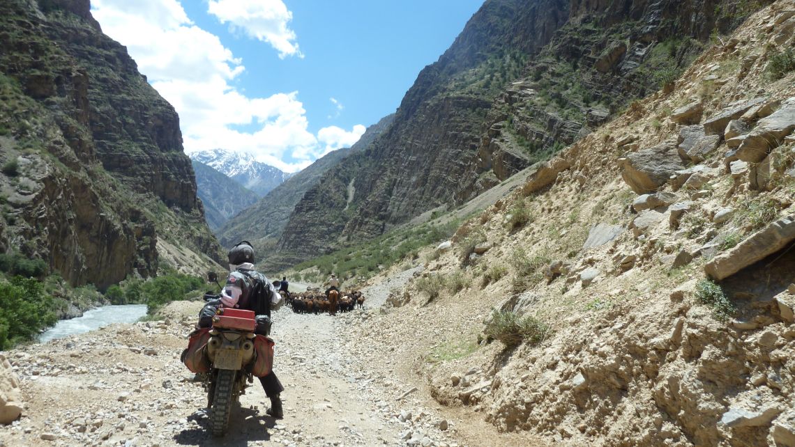
Riding with the Shepherds
We had to push our way through large herds of horses and sheep making their ponderous way up the pass, a rock wall on one side and a steep drop-off into the river on the other.
The Kyrgyz drovers, usually two or three on horseback accompanied by a few large, ragged dogs and a donkey carrying their belongings, largely tolerated our presence with an ageless phlegmatism.
About half an hour later a metal pole across the track signalled the second army checkpoint.
In a single-roomed building were soldiers and a bed. One was asleep and roused himself drowsily to speak to us. He checked our papers, asked us where we were going and then insisted, ‘Daroga nyet!’, crossing his forearms in front of his chest and shaking his head.
Not willing to give up until we were forced to, we persevered, showing the soldier the track we originally intended to take and indicating, with the same crossed-arms gesture, that the Sary-Tash road was blocked.
Eventually, we managed to persuade him and he raised the barrier to allow us through; we continued on up a track that grew still narrower and more covered with rocks that had tumbled from the steep mountain slopes all about us.
Then we came upon the third and final army checkpoint. And here the tracks ended. No vehicle had travelled further than this that we could see.
We made our way across a rickety bridge, rotten wooden slats through which the river could be seen tumbling its way down the mountainside, and made our way towards a square building, table and benches outside under a large tree, shirtless soldiers playing soccer in the heat.
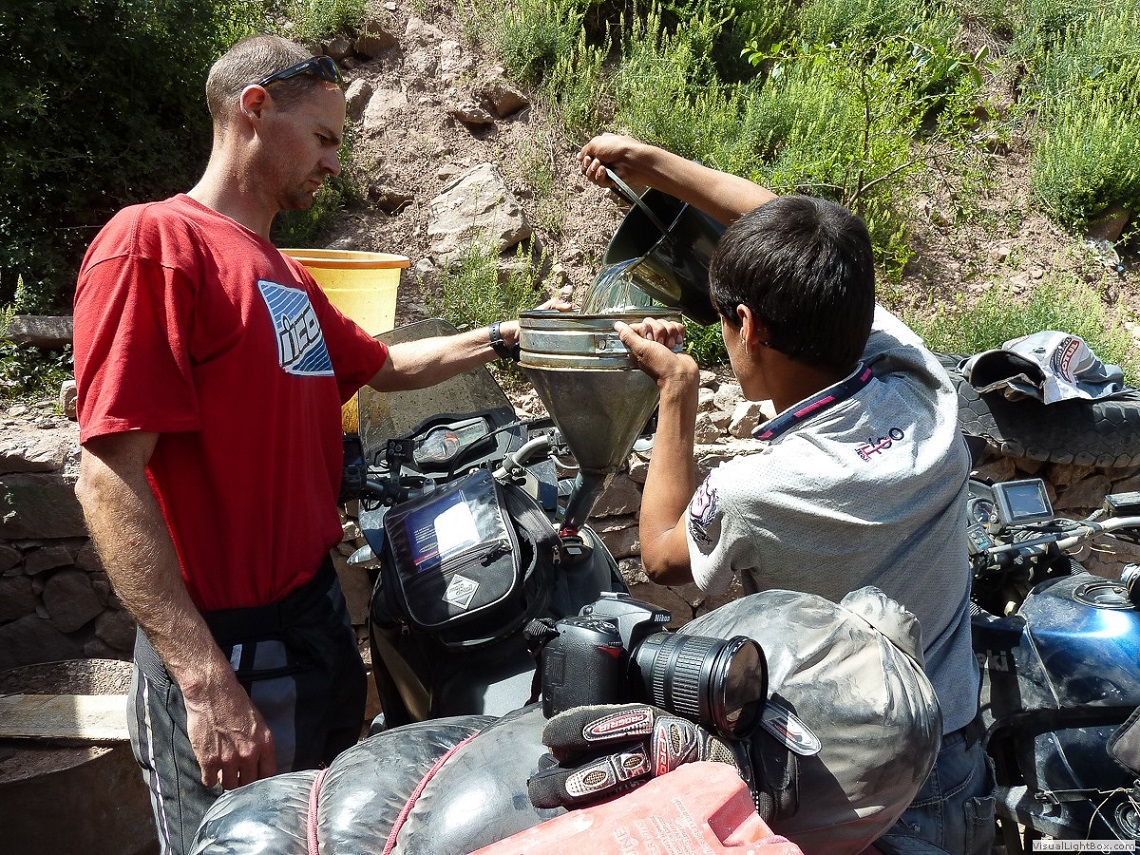
State-of-the-art Petrol Station
The officer in charge welcomed us to his barren outpost and listened politely as we explained what we proposed to do, showing him the track on our map. But he shook his head.
Using gestures and the little Russian we could understand, one of the soldiers explained that just eight kilometres from the checkpoint the track was blocked and we would only be able to proceed from there on foot or on horseback.
Again we prevailed upon them to allow us through so we could see for ourselves and we pushed on along an even steeper, narrower track, jostling once again with herds of sheep and horses plodding their way up the pass.
It was very hot and the bikes were overheating. So were we. We struggled on through breathtaking scenery, always the mountain barrier high and implacable in front of us, until, almost exactly eight kilometres from the military checkpoint, just as the soldier had predicted, our attempt ended.
The track ahead was completely covered with a thick, sloping layer of scree. I accelerated into the loose stones but bogged down almost immediately.
A metre to my left dislodged rocks dropped off into the river fifty-foot below. I tried once more to get moving but the moment my rear wheel began to turn, it slipped sideways closer to the drop.
While I waited, more scree slid down the mountain and pooled like water around my wheels and feet, starting to cover them.
Fortunately, I wasn’t riding alone and soon Gareth had made his way up to me and we manoeuvred my bike across together.
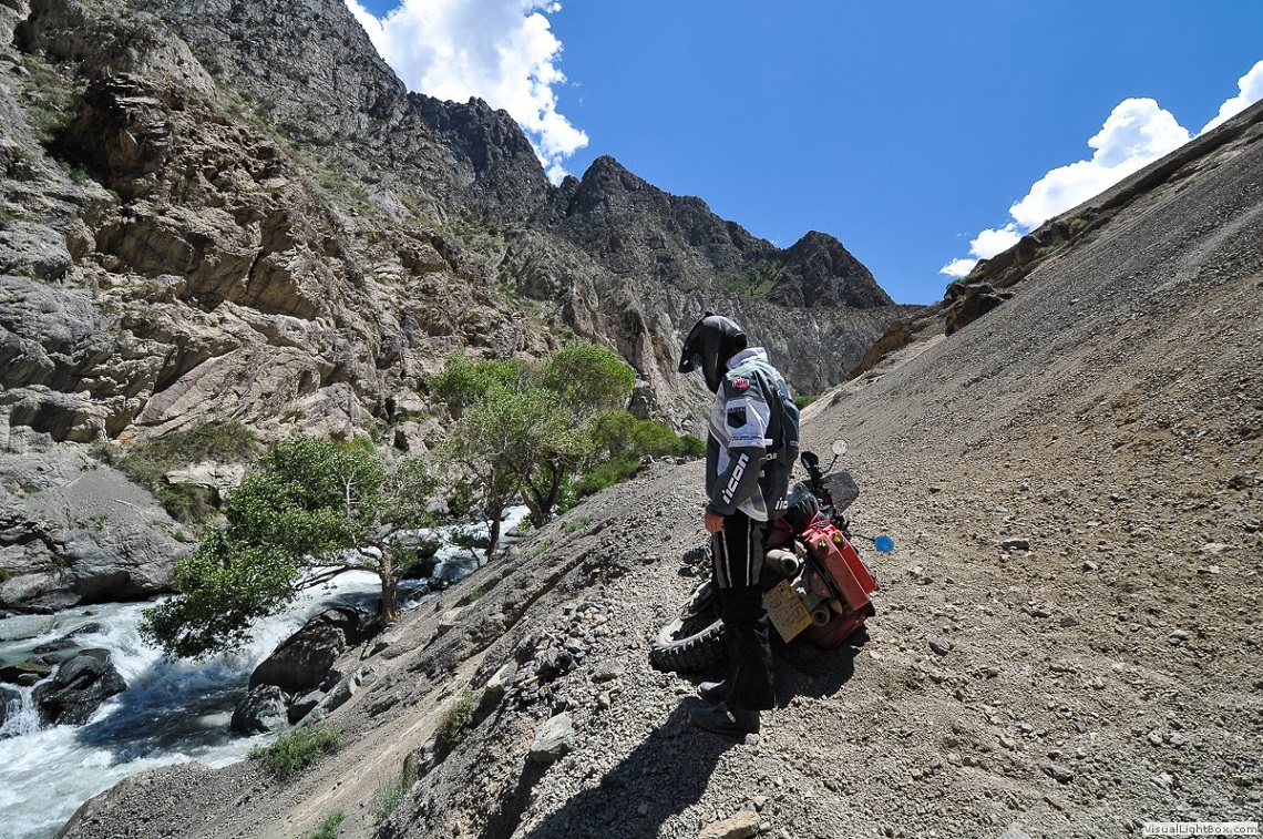
Gareth on the scree slope, the point where they realised they could go no further
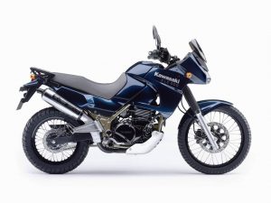
Lawrence rides a Kawasaki KLE500, sadly no longer manufactured. This is his second KLE, the first having served him well on trips to Russia, Albania, Morocco and Central Asia.
–
It is a thoroughly reliable big trailie, powerful enough when fully laden to cope with deep Saharan sand and cruise all day at a steady 70mph on a motorway.
–
But most important, it’s still light enough for the old man to pick up, fully loaded, when he drops it.
–
Gareth rides a big KTM990 which he chose because it too has a reputation for reliability, is designed for serious off-road travel and its 115hp gives it all the grunt he needs.
–
It’s like a dirt bike’s big brother, capable, powerful and unassuming.
Gareth then tried to power his way across on his big KTM but he too bogged down in the loose tumble of stones.
It was impossible for just the two of us to get the heavily-loaded KTM across so we unloaded it, dragged it on its side further away from the edge and, again both pushing and accelerating, made it across.
We could see that the track continued on its way up the mountain but we both realised it was the end. Clearly, this was a track used by drovers taking their animals across the pass and not intended for vehicles.
We hadn’t even climbed a third of the three thousand or so metres that lay ahead of us and already we were struggling. And so, thirty kilometres from the top – as the crow flies – our attempt came to an abrupt end. Reluctantly we turned the bikes and made our way down the pass.
The soldiers at the third checkpoint smiled wryly when they saw us returning. They offered us tea and gave us a loaf of flatbread and we spent a pleasant half-hour with them in their Spartan, isolated outpost high in this desolate but beautiful place.

‘Distances here are Deceptive’
So, there was nothing to do but set off on the long, six-day detour west and then south to Dushanbe to get around the rockfall. This was a long, hard slog.
From the UK it’ll take about two weeks’ hard travel to get into the Pamirs whatever route you decide to take.
–
Unless you have unlimited time, the easiest alternative, although expensive, is to fly the bikes in.
–
Fortunately, there are companies that do this every day and they eliminate all the hassle. We used JCS Motorcycles, a division of James Cargo Services (www.jamescargo.com) and they crated the bikes for us, flew them out and sorted all the documentation.
–
We also employed the services of a shipping agency called Colos in Kazakhstan to get the bikes through customs – money well spent.
–
Their agent, Dauren Dzhanaev ([email protected]), was most helpful, picking us up from our hotel and taking us through the official minefield of customs.
–
Cost: Flying the bikes out cost approximately £1,400 (depending on the size of the bike).
–
Add to this £100 or so for the agent and transporting the bikes out of the customs shed to the road.
The road (a section of the Silk Road) is pretty badly beaten up by the many heavily laden trucks that crawl through this mountainous region and, at times, we wondered just how the bikes could stand up to the beating they were receiving.
The heat in the lowlands was oppressive, over 40°, yet when the road climbed over mountain passes, snow was thick on the ground. Distances here are deceptively vast and we were riding between 8 and 12 hours a day just to make sufficient progress.
Our soft panniers began to disintegrate and my exhaust mountings broke off but we managed to strap it up with pieces of fence wire. Finally, we reached Dushanbe and turned southeast towards Khorog, the setting-off point for our dip south to the Wakhan Corridor.
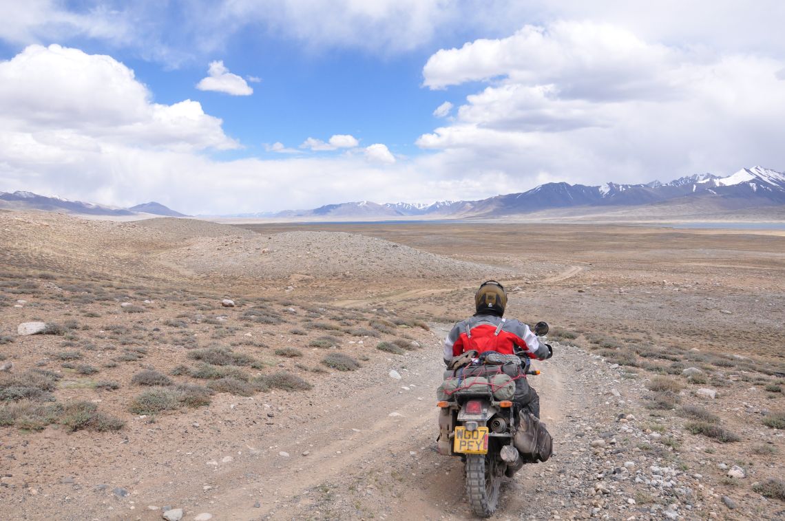
And this isolated corner of the world, tucked inside the tectonic push and shove of mountains and high Alpine plateau where Afghanistan, Kyrgyzstan and China rub shoulders in an uneasy and suspicious relationship, was the highlight of the trip: isolated and remote, almost devoid of people – just a few Tajik shepherds and their families living in adobe shacks high up in the mountains, poor people scraping an existence in this harsh terrain but whose hospitality towards us was touching in the extreme; clear streams running alongside the track, snow-capped mountains a constant presence – the Pamir Mountains to the north and the Hindu Kush to the south, Afghanistan just a stone’s throw away, Bactrian camels making their solitary way just across the river.
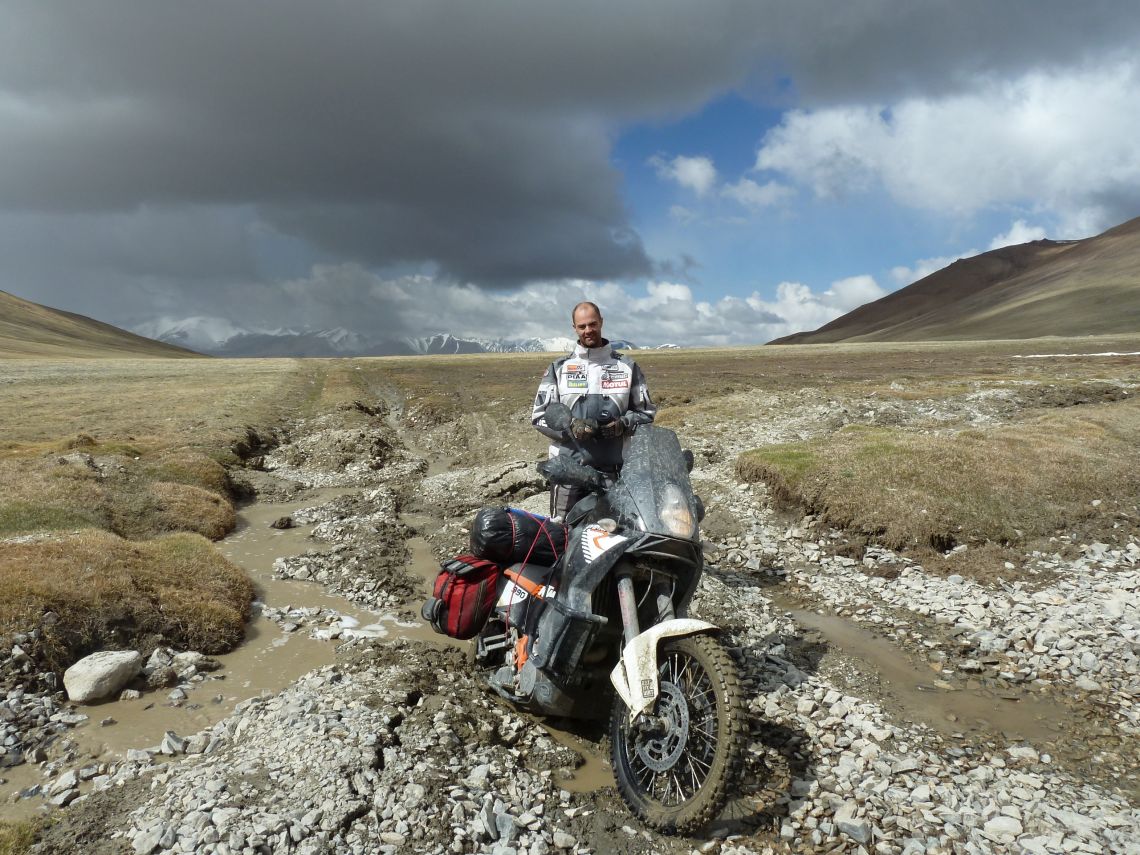
Gareth stuck up to the hubs in mud
At Khargush, the Pamir Highway turns north. The road was blocked by an army checkpoint but we managed to persuade the officer in charge to allow us to continue east towards lake Zorkul and the Chinese border.
The ’road’ degenerated into a jeep track, sometimes no more than two-wheel ruts across the high Alpine plateau, occasionally disappearing so we had to range about to find it again.
Lawrence details the full journey across Central Asia with his son, Gareth, in his book Wakhan Corridor: A Motorcycle Journey into Central Asia which can be found online on Amazon or at www.lawrencebransby.co.uk.
We camped alongside lake Zorkul as a light snow began to fall. By now, Gareth’s KTM was battling with the altitude – some sensor not functioning and he was using double the expected amount of fuel and struggling to keep the engine going at low revs.
A lot of clutch slipping, especially when crossing the many small rivers (and when getting stuck up to the hubs in mud).
Finally, we came to a small village where we hoped to get fuel but there was none. We didn’t have enough to reach the next town – unless we got the bikes over a rather deep-looking river.
Fortunately, it was spanned by a narrow, tatty-looking footbridge that a local man assured us would take the bikes so we stripped off all our luggage and gingerly made the crossing.
Still not knowing whether the landslide had been cleared, we continued on our way, re-joining the Pamir Highway at Murghab and heading north, back towards Kyrgyzstan.
We were running out of time. Fortunately, when we got there, a narrow, one-lane gap had been bulldozed through.
Then it was the long ride home: 1,700 miles across the flat desert-like steppe of Kazakhstan and into Russia; 1000 miles across south-west Russia, into Ukraine (north where there wasn’t any fighting) then across Poland, Germany and on to Rotterdam where we took the ferry to Hull and home.
