Mike Beddows is in two of England’s most popular National Parks exploring green lanes in the Peak District and North Yorkshire Moors
Green lane 13: North Yorkshire Moors
Rudland Rigg 10 miles
North Yorkshire is England’s largest county, covering 3,104 square miles; this popular area is also home to the North Yorkshire Moors National Park. The moors are one of the largest expanses of heather moorland in the UK and cover an area of 554 square miles.
The North York Moors rise to 427m. There are three or four roads that cross north-south, and Rudland Rigg is a popular rough-stuff route. At 10 miles long it’s the longest legal trail in North Yorkshire.
Rudland Rigg is a fantastic, long trail, and as well as the north-south route, there’s also one that goes west-east and intersects with it. There’s a very difficult descent at the end of the north-south trail on the northern end and the option to exit the trail using the west route means that a lengthy section can still be enjoyed by beginners.
There are many trails leading off from the main route. These are hunting access tracks and must not be used by motor vehicles; there are plenty of signs reminding users to stick to the main trail, so keep an eye out for these and stay on the legal route at all times.
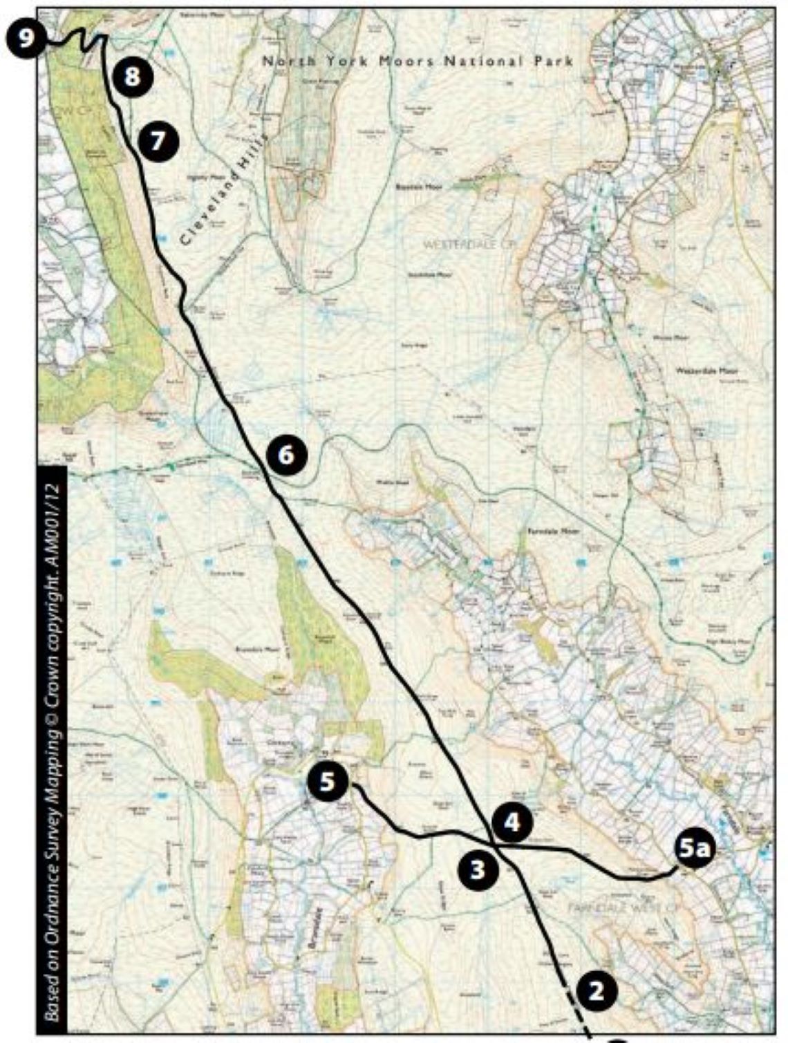
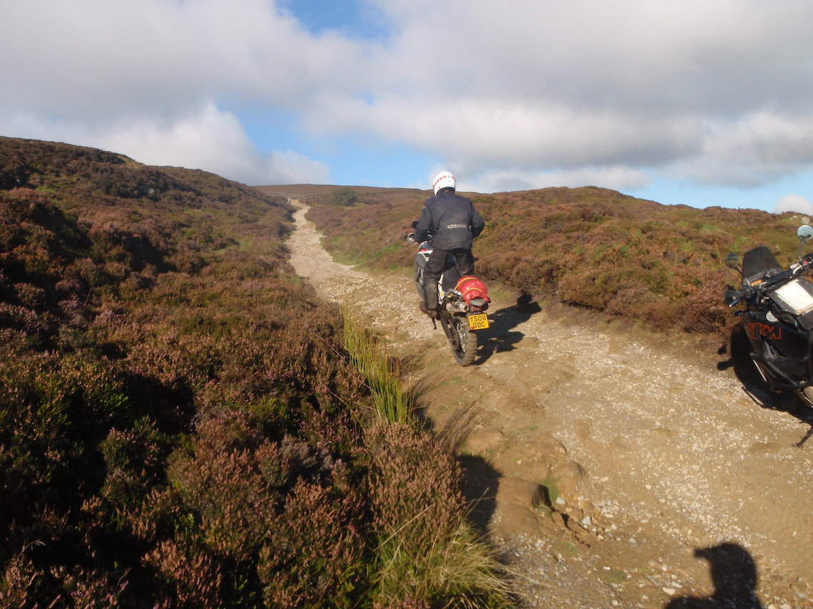
1-2 The trail starts as a wide track with a sandy, rocky base. The outset is fairly easy and won’t prove a problem for most ABRs. There are great views all the way along the trail. At around 1.9 miles there’s a triangulation (trig) point on the left used for mapping the area. It’s well worth parking the bike up here and walking to see the views.
2-3 The trail becomes more graded and has lots of shallow puddles to splash through. At about 2.6 miles the route ahead can be seen stretching into the distance.
3-4 The graded section has ended and the trail once again becomes a wide, easy track with a rocky, sandy base. Continue downhill to the intersection. Go left for the beginners’ route; right if you’re after a challenge.
4-5 At the intersection, take the left turn and descend the hill to exit the trail (1.12 miles, ABR difficulty rating 2). Once again, the views are fantastic on the way down. Feel free to continue along the length of the main trail, but be aware that the exit at the end of the trail is not suitable for beginners. Less experienced riders may wish to turn around and either exit the trail here at the left fork, or follow their tracks back to the beginning.
4-5a This exit is a bit more difficult and is better suited to competent trail riders (1.28 miles, ABR difficulty rating 3). The descent is technical in parts but shouldn’t prove a problem for more experienced riders.
5-6 The trail continues and is fairly flat. It’s pretty easy and has a hard-packed base with the occasional sandy patch. Continue to intersection with walking trail.
6-7 Continue to 8.6 miles. Take the left-hand fork. Beginners may want to turn around here as the left fork becomes progressively more difficult. It’s a shame the Cleveland Way to the right doesn’t have vehicular rights as it looks a fantastic route, but under no circumstances should you continue down this track as it’s for non-motorised traffic only.
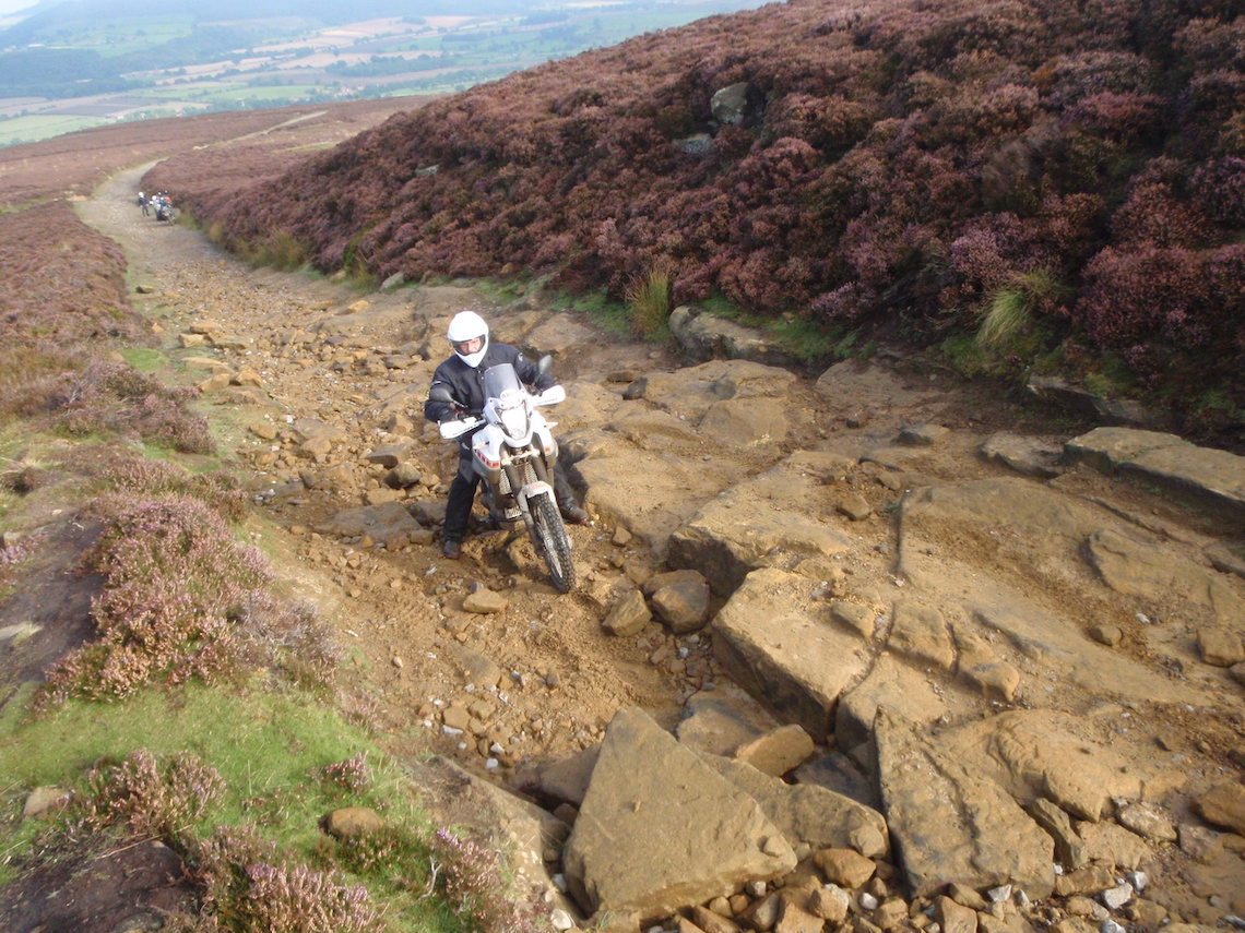
7-8 At 8.8 miles the trail is at its trickiest with an ABR difficulty rating of 3-4. There are several rock steps to bounce down. This section is definitely not suitable for beginners; it is, however, extremely challenging and fun to do in reverse (ABR difficulty rating 4). I have witnessed several bikes being dropped on this section, so be warned!
8-9 Continue down the track. The descent after the rock steps is fantastic. The trail ends at 10 miles.
Route facts
Distance: 10 miles
Nearest town: Pickering to the southeast
Maps: OS Explorer Map OL26 (trail start), OL27 (trail end)
Start/end grid reference: SE659927/NZ592062
ABR difficulty rating: 2-4 (see route pointers for beginners’ section)
Wow factor: 4
Other trails: There are some fantastic trails in the North Yorkshire National Park, including several lengthy, easy ones. There are also plenty of harder trails for the more advanced. See www.adventurebikerider.com for member-organised ride outs
Did you know?
Throughout history, people used tracks across the moors to carry goods on ponies and mules. A lot of these routes naturally followed the high ground, to avoid the boggy lowland and became known as ridgeways; Rudland Rigg is part of one of these medieval ridgeways.
Green lane 14: The Peak District
Three Shires and Sparbent 3.56 miles
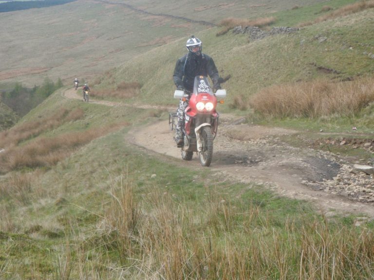
These two trails are located close to one another and in my opinion are the two best lanes in the Peak District. They are quite technical in sections however and are therefore better suited for competent riders. For this reason, these trails have been given an ABR difficulty rating of 3-4.
Take extreme care while riding Three Shires. It leads to a very picturesque location and is very popular with walkers and mountain bikers, so it’s likely you’ll be sharing the trail with other users.
Three Shires leads to Three Shires Head, a point where four packhorse routes meet. It’s also the exact location where three counties meet: Derbyshire, Cheshire and Staffordshire, hence the name.
There is a fabulous high-arched stone packhorse bridge beside which is Panniers Pool. It’s a very scenic location and several small waterfalls can be seen cascading over the rocks here.
Both these trails can be completed in both directions.
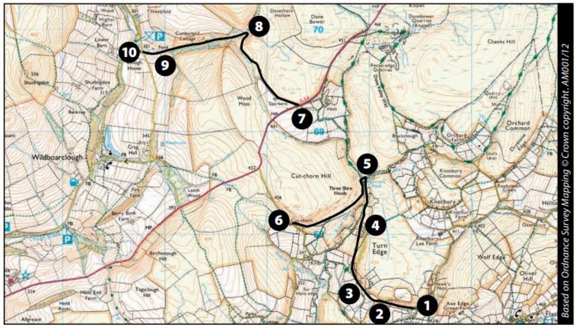
1-2 Review a map, or use the grid reference (SK011674) to locate the start of Three Shires as it’s not the easiest to find. Start by passing through a gate. Follow the tarmac past a house on the right. Take care to ride slowly here as the residents obviously experience a lot of trail traffic.
2-3 Take the right-hand fork and the trail starts. It’s an easy start as this part of the trail is used by a residential house.
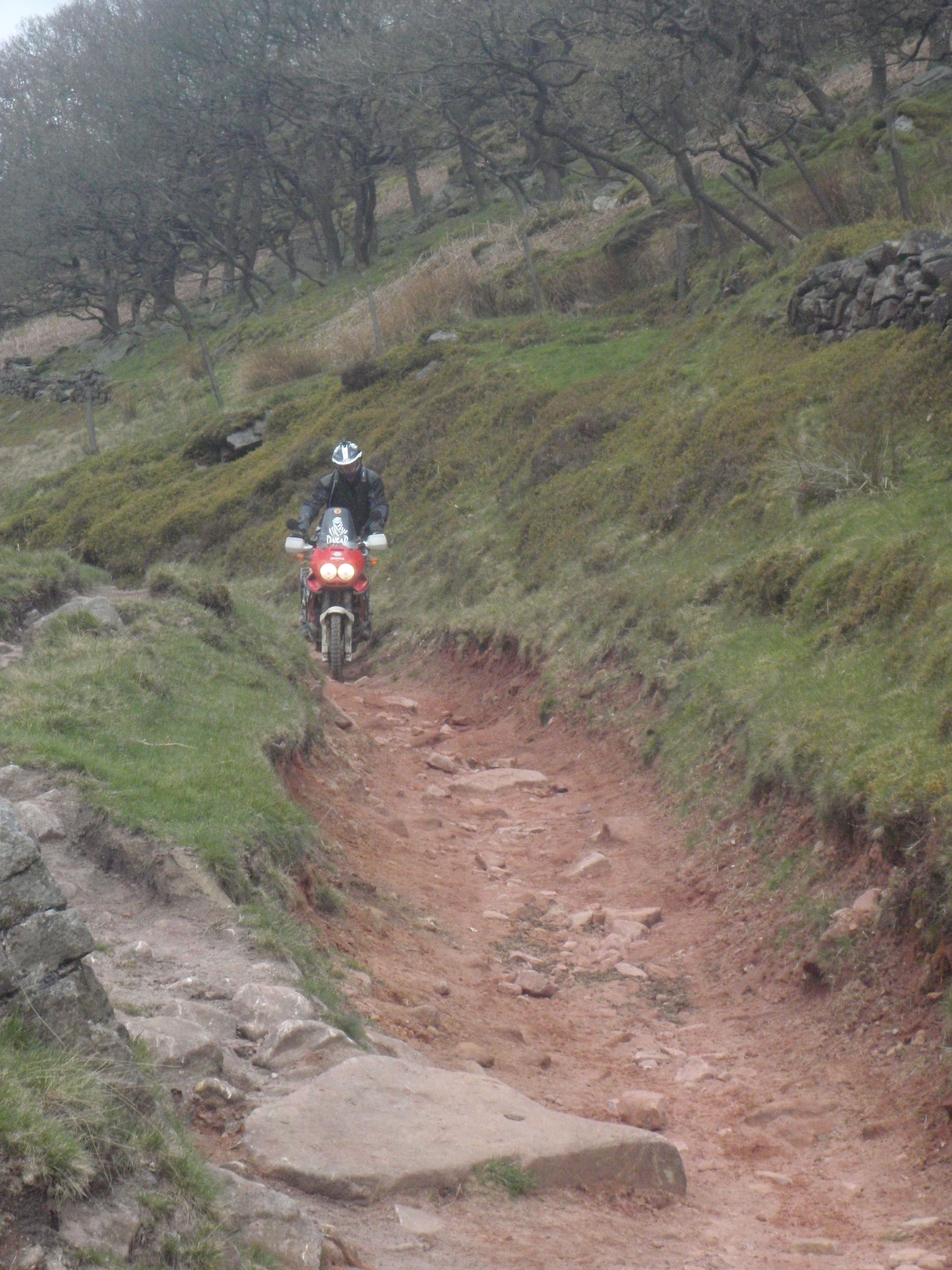
3-4 Make sure you take the left-hand fork here; the right-hand one leads towards the residential house. The trail is just big enough for a motorbike now, so no risk of 4WD traffic. The trail base is a mix of rocks and loose sand with a few deep puddles. There are some technical sections here and it’s possible to ground the bash plate if the wrong line is taken.
4-5 Proceed through the gate. Do not go left. Proceed up the hill and take care as there is a steep drop to the river on the left. There are great views looking forward towards Panniers Pool.
5-6 Arrive at Panniers Pool. Cross the bridge. There is a fairly steep step to get up onto and off the bridge. Turn left and the trail continues with the river down to the left. After a couple of hundred meters the trail diverts away from the river. The next section is fairly technical with lots of fist-sized rocks. If you lose momentum it may be difficult to get going again. Continue to the end of the trail and finish at the gate just before you reach the road.
6-7 Travel for approximately 1 mile of the road to reach the entrance to the next trail, Sparbent.
7-8 Take care at the entrance to this trail (SK003693). It’s just off the busy A54 and the entrance doubles back on the road from which you’ve just emerged. Proceed through the gate. The first section of the trail is fairly straightforward and should prove no problem for competent riders. There’s a mix of rocks, washouts and muddy sections.
8-9 At the next gate take a look back and view the waterfall that flows under the trail. This is especially spectacular after rainfall. As the trail descends with a wood on the left, the ground becomes pretty technical. There are a lot of loose rocks, some big stones and lots of tree roots to bounce over. This section is fantastic in reverse (ABR difficulty rating 4).
9-10 Take care when approaching the river crossing. There are a few small rock steps and slabs of rock to ride down. The base of the crossing is loose rock, but under normal circumstances the river should be shallow and clear.
10-11 Proceed to the gate where the trail ends.
Route facts
Distance: 3.56 miles (including 1 mile of tarmac)
Nearest town: Buxton to the northeast
Maps: OS Explorer OL24 (White Peak area)
Start/end grid reference: SK011674/SJ988698
ABR difficulty rating: 3-4
Wow factor: 5
Other trails: The Peak District has some of the best trails in the country. Unfortunately they’re slowly being made off limits to motorised vehicles. Keep an eye on www.adventurebikerider.com for member-organised ride outs or employ the services of a local guide to get the best out of the area.
Back in the 19th century, Three Shires Head was a popular spot for criminals to evaded capture as it was only possible for the police to act within their own county limits. By crossing over into the next county, villains were effectively saved from the not-so-long arm of the law.
Who’s riding?
Mike Beddows, 35, is from Runcorn, but he’s a Yorkshireman at heart. He likes trail riding and wild camping and dislikes tarmac. This year, Mike’s planning to trail ride across England from coast to coast. He dreams of circumnavigating Australia with his wife, once the kids have all grown up.