Located in the northwest of Wales and home to the country’s highest mountain, Snowdon, Snowdonia is a land fraught with legends, myths and incredible scenery. From the stomping grounds of the legendary King Arthur and his knights to some of the UK’s most beautiful valleys, the national park is full of intrigue.
Fortunately for us, dissecting the 823 square miles of Wales’ first national park is a network of roads that transport over 3.6 million tourists a year across the mountainous terrain.
With figures like this, you can expect the main thoroughfares to be heaving with traffic in peak times, but venture off the beaten track and you can find mile upon mile of deserted, lonely mountain roads which the majority of visitors either don’t know about, or don’t care to drive down (their loss).
The 200-mile long route that we have plotted here, and which is available to download from the ABR forum HERE, takes us on a circuit of Snowdonia, starting and finishing on the enchanting shores of Lake Vyrnwy.
Along the way we’ll visit the ancient capital of Wales, Machynlleth (pronounced Mack-un-cleth), the legendary Beddgelert and, of course, the route takes you around Snowdon, providing you with stunning views of the imposing peak.
A motorcycle tour through Snowdonia
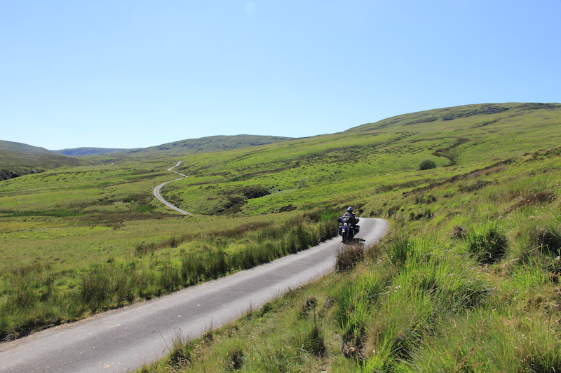
On the road from Lake Vyrnwy to Bwlch y Groes
This route has been designed to be ridden in a single day, though there’s no denying it’ll be a long one. That being said, you’ll be enjoying yourself so much that you’ll lose all perspective of time, and when you roll back onto the shores of Lake Vyrnwy you’ll be wondering where the day went.
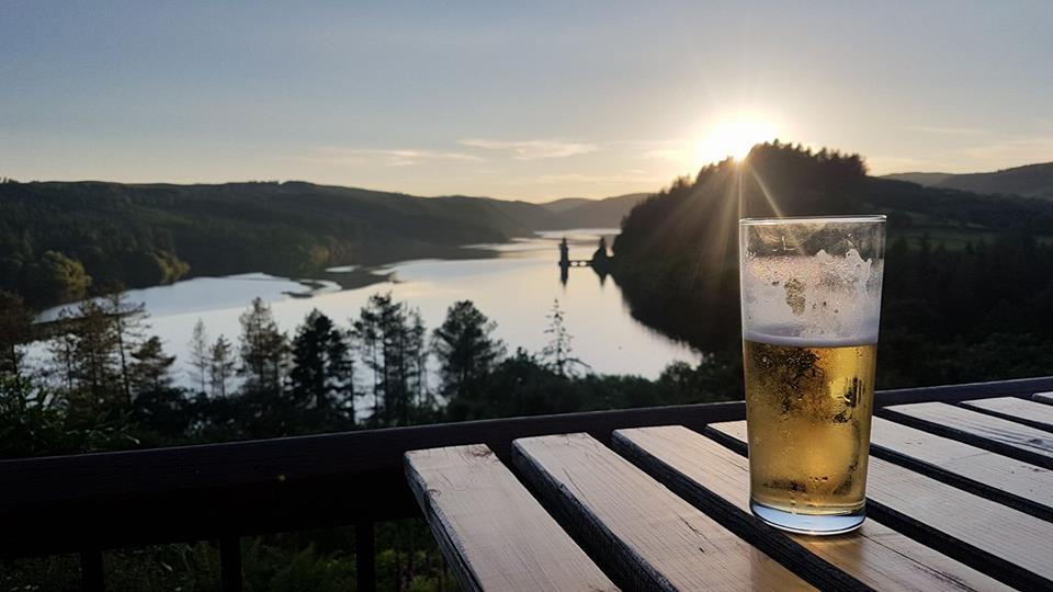
To make the most of the ride, and to avoid rushing, unless you live within easy reaching distance of the national park, I fully recommend rooming up in the Lake Vyrnwy Hotel & Spa. This luxurious hotel overlooks the reservoir with world class views, the rooms are supremely comfortable and the food is exactly what you’ll crave after a long day of riding, plus there’s not much better in life than relaxing on the terrace with a cold beer while looking over the serene landscape below.
Getting started
So, you’ll need to put Llanwddyn, located on the southeastern side of the lake, into your SatNav to reach the start point of this route. Mankind’s contributions to Snowdonia, and indeed the rest of the country, haven’t exactly been the best when it comes to adding to the scenic delights of a location, with big mines scarring the landscape (as you’ll see in Blaenau Ffestiniog) and seemingly pointless walls cutting up the land, but we’ve done pretty well with Lake Vyrnwy.
Before the 1880s, River Vyrnwy flowed through the base of the valley all the way to the River Severn, and the small village of Llanwddyn sat at the head of the dale. Today you’ll find a beautifully constructed dam that was built and designed by a chap called Dr George Deacon in order to create a reservoir that could supply Liverpool with fresh water.
It was proposed that in order to build the dam, the small village had to be sacrificed, and so the reservoir flooded Llanwddyn, and the beautiful lake was created.
We follow the southern coast for its length, before branching off to ride a small single-track road up Eunant Fawr valley which leads to the boundary of Snowdonia National Park. Speed isn’t on the agenda here as the small road twists and turns as it gains altitude, and you’ll have to dodge suicidal sheep as they dart out in front of you.
The riding is glorious for a few miles before you crest a ridge and one of the most impressive valleys in the United Kingdom reveals itself below you, the beginnings of the Dyfi Valley, which eventually forms the Dyfi Estuary.
Exploring the highest Welsh roads

Stunning views down the Dyfi Valley on Bwlch Y Groes
Here the road converges with Bwlch Y Groes, the Pass of the Cross (also known as Hellfire Pass), a wonderful mountain road that is on a pilgrimage route between north and south Wales, which is also the second highest road in the country.
Interestingly, it was also here where the old Austin Motor Company, Triumph and BSA used to test their vehicles out, testing the brakes on the way down and the gearbox on the way up. At the T-junction we turn left, but if you were to head right you’d eventually emerge by Lake Bala.
After following the road for a few miles you’ll pass through a non-descript collection of houses in a place called Abercywarch. On your right, you’ll notice a signpost pointing to ‘Cwm Cywarch’ and a dead-end sign. I imagine a lot of people simply carry on past this turning, thinking that there’s nothing of note up the lane, but I would recommend you do the opposite and take 20 minutes or so to explore.
The road takes you down a beautifully isolated valley to a car park at the end of the dale where you can read about the significance of the place. I’ve heard that this valley was, technically speaking, where the industrial revolution in Britain began. Here, lead was mined extensively from the mountains, though there’s little evidence of it today save for a few pretty stone buildings, including the mining company’s headquarters.
Stepping briefly out of the national park
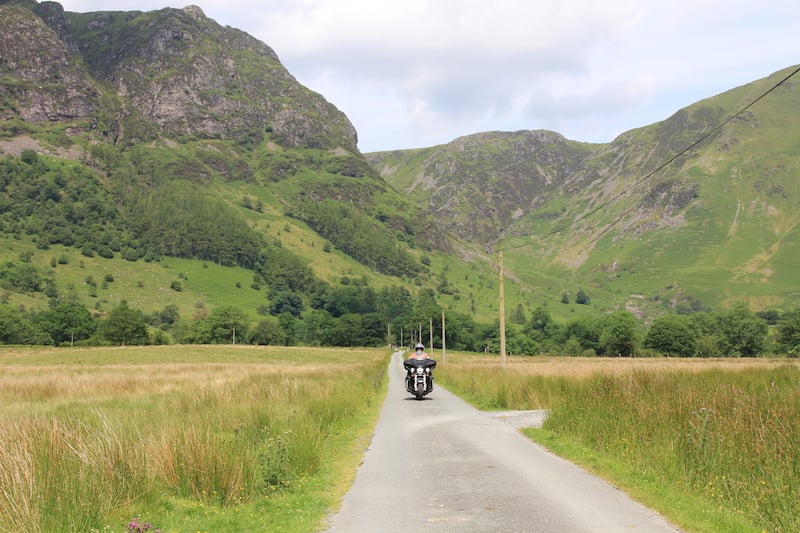
The almost deserted mining valley of Cwm Cywarch
Back on route and we pass through Dinas Mawddwy before joining the fast-flowing A470 to Machynlleth. While this route is called the Snowdonia Discovery Route, this section is outside the boundaries of the national park, but it’s a necessary journey, and an enjoyable one at that.
Machynlleth is known as the ancient capital of Wales, and while it has never officially been called a capital, or even a city, it was here that the last Welsh prince of Wales, Owain Glyndwr, held Welsh Parliament in 1404. It’s a great place to stop for a brew, so take the opportunity to do so.
From Machynlleth we head towards the coast, hanging a left after crossing the Dyfi bridge. If you’ve got the time and interest, take a short diversion to the right to visit the Centre for Alternative Technology, an eco-centre that demonstrates sustainable living methods. Further down the road still, is King Arthur’s Labrynth, a fun attraction where you can explore an underground river while discovering more about the story of the legendary British leader.
Back on track we ride the A493 towards Aberdyfi. Now, this road has the potential to be an absolute delight, or a nightmare. It’s popular with slow driving tourists and vehicles far too large for the tight twists and turns, but we’re not on it for too long because when we reach the seaside town of Tywyn we head inland on the brilliant B4405.
Seemingly hidden from the caravan trains of the coastal roads, this delightful, fun route takes you through a beautiful valley and along the shores of Lake Mwyngil before you join the A487 and begin a magnificent ascent up the valley wall at the foot of Cadair Idris, a mountain which was once said to be the seat of a giant called Idris.
Discover the best motorcycling in Britain with this free guide
Looking to explore the best riding the UK has to offer? Look no further than the TomTom Guide to Motorcycling in Britain, which is completely free to download.
Over 96 pages we’ll detail some of the best routes you can ride over the course of one, two, or even three days, as well as the highest passes and most spectacular roads. Download your free guide HERE, and get planning. Ride safe.
A land rich with history and legend
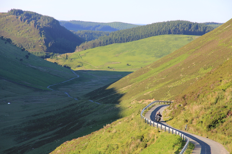
Lonely mountain roads between Lake Bala and Lake Vyrnwy
The mind can wander so much as you journey through a land so rich with history and legend, and before long we’re rolling along the Aberglaslyn Pass and into Beddgelert, a delightful village that got its name from a tragic story of mistaken identity.
As the story goes, in the 13th century, there was a Welsh prince, Llewellyn the Great, who had a trusty hound called Gelert. One day, Llewellyn went out hunting, leaving Gelert at home along with his son and heir. Upon returning to his abode, he was greeted by an enthusiastic Gelert who was smothered with blood.
Sensing something was amiss, Llewellyn also discovered his son’s cot overturned, bedclothes scattered everywhere, blood on the floor and no baby to be found. Thinking that Gelert had slaughtered his son, Llewellyn thrust his sword into the dog’s side, and as Gelert let out one final yelp, the sound of a child crying filled the air.
Llewellyn searched and found his son unharmed, but next to him lay the body of a huge wolf which Gelert had slain. The prince was filled with remorse, and it is said that he never smiled again, and just a short walk from Beddgelert you’ll find Gelert’s Grave, a stone monument which marks the resting place of the poor pooch.
While the story of Gelert’s untimely death is a tragic one, testing of the cairn at the site of the grave revealed that it had been build 200 years ago, and it appears that it was made up by a chap called David Prichard who owned the Royal Goat Inn (now the Royal Goat Hotel) as he wanted to attract more tourists to the area – and what a stunning job he did.
As well as visiting Gelert’s grave, when passing through Beddgelert make sure you stop at Glaswyn Ices for some of the best ice cream you’ll taste.
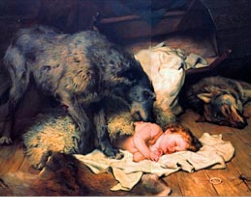
The wrongly convicted Gelert
Views of Snowdon
Just past Beddgelert you’ll begin your ascent up the A498 where you’ll be treated to a magnificent view of Snowdon’s imposing south face to the left. The temptation is to head left and towards Llanberris when the three roads converge at the top of the pass, but carry on towards Capel Curig, and our next stop is the mighty mountain of Tryfan, which is best approached from the east.
The A5 provides a short respite from the slow, singletrack lanes that you’ve just been riding on, and within a few minutes you’ll see the formidable peak of Tryfan approaching on your left.
With its classic shark-fin look, this is the only mountain on mainland Britain that you cannot walk to the top of, every route of access requires either climbing or scrambling. On the top of the peak you’ll be able to make out two stone monoliths, so perfectly placed that it’s hard to imagine that they weren’t put there by design, that have been nicknamed Adam and Eve.

The shark-fin ridge line of Tryfan from the A5
Onward from Tryfan we continue our ride down the A5, the mountains rising dramatically from both sides of the road. This area of Snowdonia is magnificent and your neck will be strained as you admire the immense scenery.
From Bethesda, you’re presented with two options. If you’re running out of time I’d suggest you head down the A4244 and join the A4086 which will take you up the spectacular Pen Y Pass, at the summit of which you’ll find the most popular starting point for an ascent of Snowdon.
If you’ve got time to spare then you can continue to Caernarfon to see one of the most formidable, beautiful and well-preserved castles on British shores, Caernarfon Castle. From here our route almost doubles back on itself, taking you up Pen Y Pass as well.

Pen-y-Pass
The day is nearly done, but there are still some fantastic roads to be ridden in Snowdonia, so from Betws-y-Coed we head down the beautiful, but fast flowing and fun A470, briefly travelling through the mining scarred hole in the middle of the national park, before turning off up an unclassified country road that will take you to Bala.
This 13-mile stretch of road between Bronaber and Llanuwchllyn is not to be missed, and despite riding it on one of the busiest days of the year so far, we didn’t pass a single car along the way.
From Bala, the ride to Lake Vyrnwy is equally as stunning, with the road clutching to a deserted valley wall before depositing you on the northern shores of the lake at which you started.
It’s just a five minute ride to Lake Vyrnwy Spa & Hotel from here, where you can enjoy excellent food with an even better view – and if you’ve booked yourself in for the night, a well deserved cold beer.
Snowdonia route
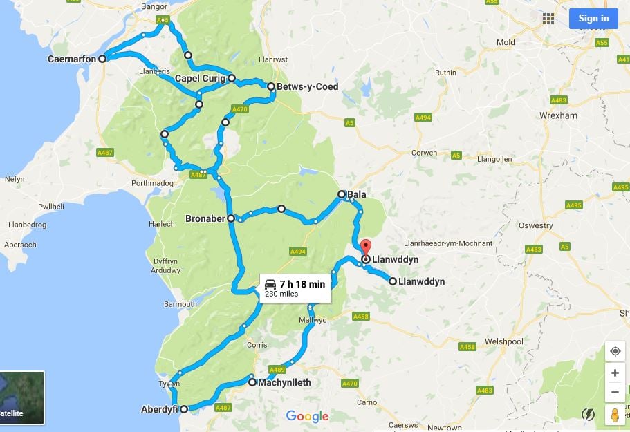
Enter the following waypoints into your SatNav to follow, as near as dammit, the ABR Snowdonia Discovery Route (the route is also available to download by visiting this page):
Llanwddyn
Dinas Mawddwy
Machynlleth
Aberdyfi
Beddgelert
Capel Curig
Bethesda
Caernarfon
Llanberris
Betws-y-Coed
Bronaber
Bala
Llanwddyn
Total distance: 230 miles
Where to stay
The route proposed here consists of a full day of riding when stops are taken into account, and when you roll up to the end of it you’ll probably be ready to call it a day.
Located just a few miles from the terminus of the Snowdonia Discovery Route, you’ll find the Lake Vyrnwy Hotel & Spa, a four-star hotel that overlooks the lake and its gothic-styled straining tower, presenting you with a view that could be straight out of a fairytale. On-site is an award-winning restaurant, a great bar, relaxing spa treatments and safe and secure parking.

