This Issue: Bwlchy Groes & The Highway
Bwlchy Groes
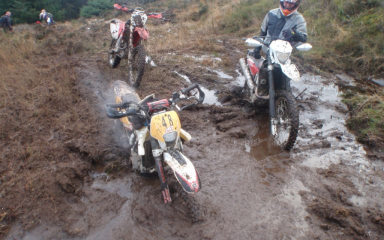
This is a very difficult trail, and is only the second I’ve graded 5. In fact, this is so tough it’s been given a max 5+ rating. This trail is as close to riding Enduro terrain as possible without actually having to enter an Enduro. I’ve seen photos of mid capacity bikes (600cc) on the trail, but I seriously wouldn’t recommend anything other than a full blown enduro bike. The smaller and lighter the better. We were on 300 and 450cc enduros, and were constantly dragging them out of thigh deep bogs.
The trail is only 2.5 miles long, but it took a small group of us three hours in one direction, and two hours on the return leg (I’ve read reports on the web of eight hours plus, one way). Definitely do not do this trail solo, and a minimum group size of three is recommended. Some of the bogs are so deep if you get the bike stuck it’s hard for two riders to get it moving again.
The trail is best attempted east to west. This is to preserve the moorland on the west side. Approaching in the opposite direction means having to ride uphill on the moorland section, and the ground is so soft serious damage can occur. Also, there is a small gate to pass through at the west end. The owners of the house here do not like riders on this trail, and although its 100% legal, it’s far better to avoid confrontation and free wheel down past his house once through the gate. Heading west to east means having to ride uphill to the gate. The owner of the house came straight out and was filming us and trying to tempt us into an argument on film that would only serve to provide ammunition to get this trail closed. So please consider these facts and ride the trail east to west. Also, take plenty of water and tools. If your bike breaks down you will have no option but to leave it and walk out unless you can get it going again.

The Route
1-2
The entrance to the trail is just to the left of the large yellow grit bin. Ride around the strategically placed rocks (to stop 4×4’s). The trail proceeds into the wood ahead. The first 100 meters is easy going, but take care as you approach a mountain bike track crossing the trail.
2-3
From here on it is a very tight, overgrown single track. There are some deep muddy ruts and lots of muddy puddles with lots of tree roots to ride over. It’s very hard to actually stand up on the pegs, it’s that tight. By the time you get up it’s time to drop back down and get feet on the floor, either due to an obstacle on the ground or tree branches overhanging the trail. Continue until you reach a fork in the trail. Park up and get your breath back.
3-4
If you think the previous section has been tough, now is your chance to turn around. The next sections are extremely tough going. Walk up the trail to the left and have a look. There is a large rock step at the bottom. At the top you will see the main trail heading off to the left. If you turn right here you will walk back down the trail to the parked bikes (forming a loop). You will have to decide which trail to take. They both lead to the same place, but both have different issues. One is not easier than the other. I am not certain which is the legal route, but can say that the right hand fork had blue markers on it so I would suggest this is the correct route to go.

Once you have reached the point where the two trails meet back up, again, park up the bike and walk up the hill. You will see many different routes on the way up. It’s basically a mess of lots of different routes to the top. All are difficult. I don’t think there is an easy way to the top. Some of the ruts are really deep and once in, the bike becomes stuck. It will be a team effort to pick your way to the top.
At the top, once again it is worth walking forward on foot, at least 150 meters. The bog ahead is deep, thigh deep to be precise in its deepest bit. And it’s very sticky smelly mud. Getting through the bog is only the first step. Once through, the ground continues to be soft and boggy until you reach a wall, approx. 150 meters away. I’ve found the best approach to get through the bog is to wheelie into it. Expect to fall off. If you try and ride in with your front on the ground it will instantly get bogged down. When you eventually get to the wall, stop and have a rest.
4-5
You have now reached the summit. It’s nearly all downhill from here, but by no means easier. Follow the single track through the trees. For the most part there is a solid base on the track, but there are still occasional boggy muddy bits to contend with. As before, it’s far easier to stop and walk than have to free a stuck bike. You will soon approach a small gully to cross. It’s easier to man handle the bike across between a couple of you. It’s all too easy to drop the bikes wheels into the gully.
5-6
Continue downhill along a single track. At the bottom is a large swamp/bog. The trail is obvious, it goes straight through the middle in a large channel of water. Do not try to go around, it’s a swamp and you will get stuck! The water is waist deep but this section is ridable. Continue along the trail to the left. At the gate, turn right and pass through.
6-7
Once past, it’s a downhill section through open moorland. The trail becomes difficult to follow so be careful that you do not go off track. Again, if you pick the wrong line you will get bogged, and if by any chance you have built up speed you will go over the bars. At the bottom the route heads to the left . The torture is nearly over now. You will reach a rocky wide track.

7-8
Turn right and follow the track as it winds down the hill. The next section is tricky to spot, but there is a small trail heading off to the left approximately 200 meters from the end. Follow this small trail but be careful as the drop to the waterfalls and stream below is a risk. If you do miss this turning, as soon as you see the houses at the bottom then stop and look for the trail on the left. Do not head down the track towards the houses and gate. This is not the way. Instead look to the left and find the path to the right of the stream. This leads to a green gate to the left of a house. This is the exit. The signage here stating, ‘report illegal riders’, refers to anywhere off the legal trail. Make sure you stick to the trail all the way and do not venture off-piste or into the forestry adjacent to the trail. Proceed carefully past the house and the road.
Yorkshire Dales/Cumbria
The Highway 3.5 miles
This trail spans the boundary between the Yorkshire Dales and Cumbria. It is an excellent trail to do but can become very exposed in bad weather. This trail can be combined with Stalling Busk that was documented in ABR Issue 20 and, as documented in that issue, Takoda Camping (or Haggs Bank Bunkhouse on page 73) is an ideal base to explore this region.
The trail is fairly straightforward and is graded a ‘2’ in the dry, possibly increasing to a ‘3’ in the wet. The views from the top are fantastic. A long section of the byway heading down to Hawes has had a TRO (Traffic Regulation Orders) for many years. This is a real shame, but I am assuming the sign along the way explaining how the moors are the largest moorland re-generation and black grouse recovery project, is an explanation for this TRO’d section. The High Abbotside moors are the largest moorland regeneration scheme and black grouse recovery project in the Pennines, and due to a habitat loss over a period of many years a scheme of heather re-seeding and general habitat improvement is taking place to ensure the continued increase in the numbers of black grouse and all other moorland flora and fauna that has been lost.

The Route
1-2
Start at the farm, take it steady passing by the farm buildings. Follow the farm access track and pass over the humpback bridge. Do not follow the track to the right, continue straight on. Proceed uphill along a hard compact 4×4 track. The base is a mix of gravel and stone, which is easy going. Halfway up the hill, there is more grass covering the trail that will be slippery in the wet. Continue to the TRO sign for the trail heading off to the right. You have now reached the highest point of the trail at 397 meters.
2-3
Do not proceed to the right, this section of the trail has been TRO’d for several years. It’s a shame as the map shows a long byway section heading down towards Hawes. Continue straight ahead towards the wood. You will cross a bridge (Hell Gill bridge) and come to a gate. Take a look over the side of the bridge. It’s a long way down a narrow rock gorge to the stream (Hell Gill Beck) below.

3-4
Proceed through the gate and continue across the grassland ahead. The grass is very slippery and it doesn’t appear that it has seen a lot of 4×4 traffic. There are shallow grassy ruts but they are comprised of grass, meaning when I did the trail it had been many months since the last 4×4 passed through. Stay to the track and do not venture off-piste. There is some exposed sections of rocks to ride over. The views are fantastic. Continue to the statue (monument).
4-5
The views from the statue are amazing. You could just imagine the glaciers flowing through the valley below that formed this terrain thousands of years ago. Continue down the grassy track, which soon turns onto a more graded section with old ruts. There are two stream crossings on the way down and some drainage ditches. Pass through the gate at the bottom and end at the B6259.
