

Get the most out of your adventure bike at home
Mike Beddows tackles two great UK lanes in two very different locations: South Wales and the Lake District
Green lane 10: Lake District
Old Coach Road, Lake District 5.2 miles
This is the longest legal trail in the Lake District and stretches for 5.2 miles from near Dockray in the east (around the northern end of the Helvellyn range) to the Vale of St John in the west. It’s a fantastic trail and the scenery is stunning; the highest point along the trail is 437m.
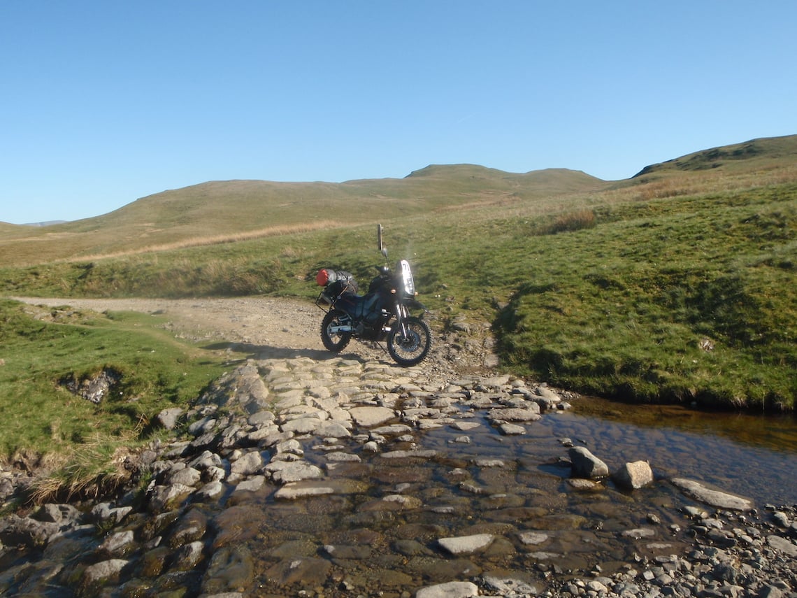
Photo: Mike Beddows

The Old Coach Road was the main through route from east to west before the coming of the railways. Near the route summit there is Hause Well, a spring issuing from a crevice in the rock.
The trail is very remote, so make sure you go prepared when you attempt it. If you have any mechanical failings along the route, you’ll have a long walk back out.
The trail is in fantastic condition. It’s also popular with long-distance walkers and mountain bikers, so take care if you encounter other users. The trail can be attempted in either direction, the easiest being from east to west. I’ve given it a difficulty rating of 2-3 as there are a couple of 3-rated sections. These should be attempted with caution if you’re a novice rider.
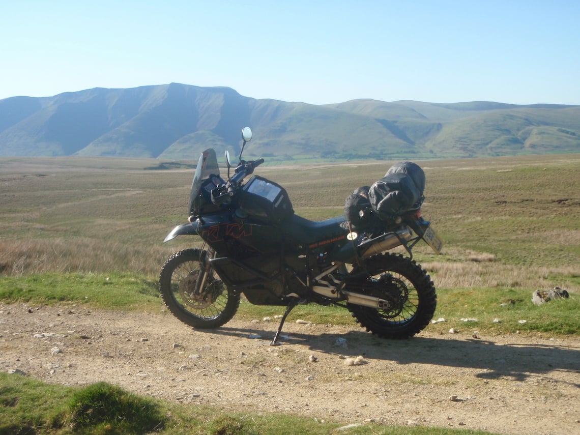
Photo: Mike Beddows
Route facts
Distance: 5.2 miles
Nearest town: Glenridding, Ullswater, to the south
Maps: OL Explorer Map OL5, The English Lakes, North Eastern 1:25,000
Start/end grid reference: NY380219 / NY316231
Difficulty rating: 2-3 (out of 5)
Wow factor: 4 (out of 5)
Other trails: There’s a fantastic network of legal trails, especially in the vicinity of Lake Windermere. See, www.lakedistrict.gov.uk. for a comprehensive list of legal trails
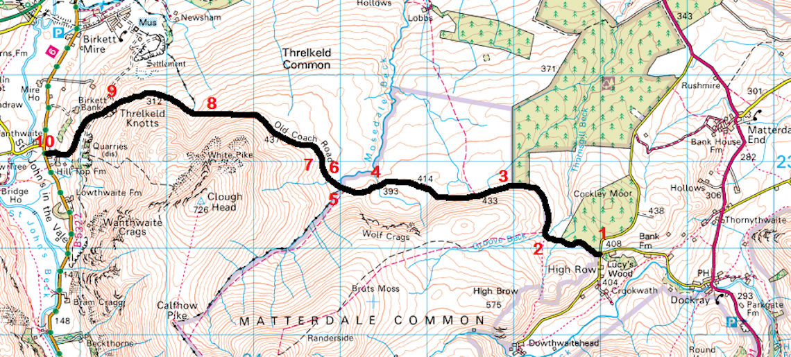
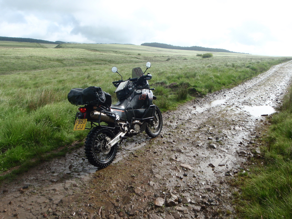
1-2 The trail starts as you proceed through a gate. It’s a well-used, well-maintained single 4×4 track with a solid base. There are several knee-deep puddles which may have an uneven, muddy base. It’s not possible to go around them as there are high banks on either side, so ride through them with care. Difficulty rating 2.
2-3 There is a very picturesque ford at 0.4 miles that has a few slippery rocks. The trail continues with a few more puddles, but nothing as deep or large as the ones in section 1-2. Difficulty rating 2.
3-4 The views really open up now to the 800m-plus mountains on the other side of the valley. The trail is a mix of hard compact stones and mud. There are more puddles here, but nothing to be concerned about. This section is harder in the wet as conditions can get muddy. Difficulty rating 2 (dry), 3 (wet).
4-5 The trail proceeds downhill and is relatively straightforward. The uphill climb on the other side may prove tricky in the wet; it’s not a technical slope but can get slippery. My advice is to let momentum take you up the slope. Difficulty rating 2 (dry), 3 (wet).
5-6 There’s slight damage to the trail (June 2012) for the next 100m section. It was dry when I did it but this section could get very muddy in the wet until it’s repaired. It could also be prone to collecting a lot of water, so be careful if you approach this route after significant rainfall.
6-7 This is the trickiest section so far as there are lot more ruts and loose stone. Difficulty rating 3.
7-8 Begin a long, rocky descent. There are lots of ruts and gullies to negotiate here. The rocky surface is loose and comprises fist- sized rocks.
8-9 It’s worth stopping here (4.3 miles) to appreciate the views of the lush green valley that stretches out in front of you. The trail continues down and contains more rocky gullies. This section will be the hardest if you choose to do the trail in reverse; it’s a long climb and will need commitment to complete it in one go.
9-10 The trail gets easier and ends when you pass through two gates and approach the tarmac B5322 road.
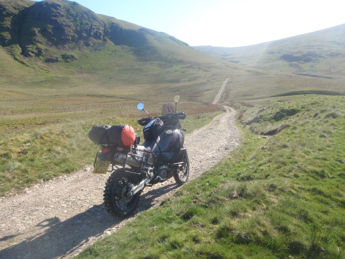
Photo: Mike Beddows
Did you know?
On 2 May, 2006, 36 trails in the Lake District, which were previously classed as Unclassified Country Roads (UCR), lost their mechanically propelled vehicular status. However, there are still 75 legal routes in The Lakes and these are made up of 14 Byways, accounting for 11 miles (17 percent) and 60 UCR’s, accounting for 58 miles (83 percent) of the remaining network.
Green lane 11: South Wales
Sarn Helen, South Wales 10 miles
The Sarn Helen was a Roman road in Wales, some 160 miles in length, running from Aberconwy in the north to Carmarthen in the south. In Issue 11 of ABR, we detailed a section of the Sarn Helen near Betws-y-coed, North Wales; here we’ll be focusing on a more popular section of this route in South Wales.
The southern section of Sarn Helen is marked on maps as a restricted byway, meaning it cannot be legally used by mechanically propelled vehicles, including motorbikes. There are also a few ‘no vehicle’ signs at various places along the trail, but the TRF (www.trf.org.uk) considers this section to be 100 percent legal for motorcycles and will assist any TRF member who’s apprehended while using the trail. If you’re not a member of the TRF, contact the local council regarding the legality of the route before riding it. I’ve ridden the route twice and never had a problem.
This part of the Sarn Helen has two technical sections and I’ve given this route an overall difficulty rating of 3, with the two technical sections classed as a 3-4. These are fairly tricky and could result in a dropped bike, which may cause damage to your motorcycle. Approached from the south, the first technical section is a downhill rocky slope with a few rock steps before a river crossing. The second is a few miles north and is a very rocky descent of about 200m. The rest of the trail is fantastic and pretty straightforward.
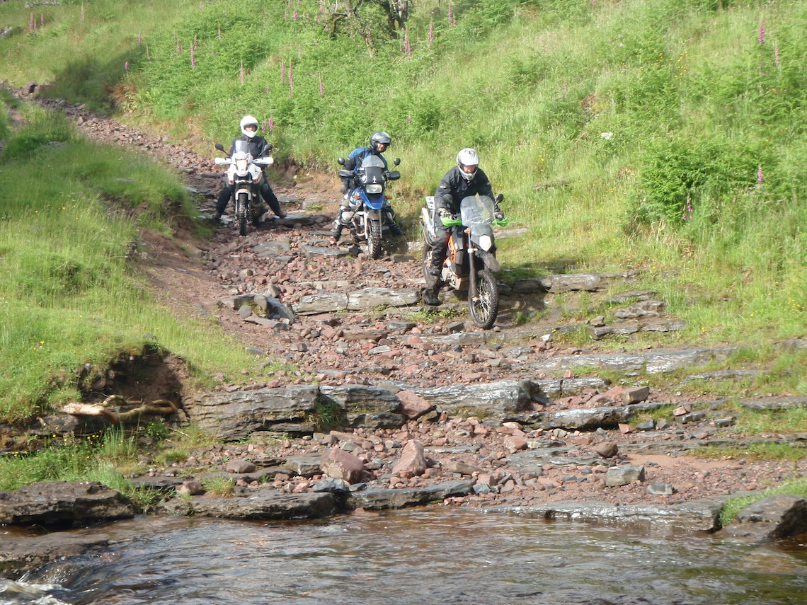
Photo: Mike Beddows
Route facts
Distance: 10 miles
Nearest town: Sennybridge to the north; Brecon to the north-east
Maps: OL Explorer Map OL12, Brecon Beacons 1:25,000
Start/end grid reference: SN878117 / SN940234
Difficulty rating: 3 (out of 5)
Wow factor: 4 (out of 5)
Other trails: Lots of trails in the surrounding area but I would recommend a local guide to get the full potential out of Sarn Helen. See, www.adventurebikerider.com for member-organised ride-outs
1-2 This section of the Sarn Helen starts as a straightforward moorland track. It’s a single car-width track with a hard, stony base. This is an easy section with a few ruts and puddles. There is a gate at 1.5 miles. Difficulty rating 2.
2-3 Proceed down a rocky descent, then on to a forest track. The forest track ends in a very rocky section with fist-sized stones. There’s a gate at 1.9 miles. Difficulty rating 3.
3-4 After the gate there are a few rock slabs. These are slippery in the wet and some are at an odd angle, so be careful. There are a few small rock steps, which you’ll need to bounce up. Nothing too technical, though. Difficulty rating 3.
4-5 Continue along a forest track leading to a gate. Difficulty rating 2.
5-6 This section is an easy forest track. At 3.1 miles, take the right-hand fork and proceed through the gate. Difficulty rating 2.
6-7 This is the beginning of a descent to a river crossing. It starts off easy, but as you bear left and the river comes in to view, the descent becomes more difficult. Difficulty rating 3-4. There are some large stones, which you’ll need to bounce over, and these lead to a few rocks steps, which you’ll need to bounce down. Proceed through the river, which may be swollen after rainfall.
7-8 After crossing the river, proceed uphill. It’s a rocky uphill climb. Continue through the gate to a moorland section, which is a mix of loose stone and broken tarmac segments. After the moor, continue in to an easy forest section. Difficulty rating 3.
8-9 This is an easy section through the forest. There may be a few shallow puddles to ride through. At 5 miles, bear right. This will take you to a tarmac road. Turn left along the road. Difficulty rating 2.
9-10 Tarmac single-track road. Difficulty rating 1.
10-11 This section is a rocky trail with some washouts and a few small ford crossings. Difficulty rating 2-3.
11-12 This is a tricky, rocky descent with lots of fist-sized and larger stones. Momentum is definitely best here. This section is fantastic in reverse. Difficulty rating 3-4.
12-13 This section is fairly easy, more graded, stony and with a few washouts. There are some great views to the left. Difficulty rating 2. Take the left fork at 9.6 miles.
13-14 Continue along the trail, which has a solid base and a few loose stones. Go through a gate and proceed to tarmac where the trail ends.
Who’s riding?
Mike Beddows, 35, is from Runcorn, but he’s a Yorkshireman at heart. He likes trail riding and wild camping and dislikes tarmac. This year, Mike’s planning to trail ride across England from coast to coast. He dreams of circumnavigating Australia with his wife, once the kids have all grown up
