This Issue: Wiltshire Fosse Way Julian Challis details a fantastic run along the Wiltshire Fosse Way
Littleton Drew to Kemble
From the number of riders that tried out the Adventure Trail at the recent ABR Festival and the smiles on their faces, it’s very obvious that our readers genuinely enjoy taking their bikes off-road when given a chance. However, it was also very evident that many riders, particularly those on the big bikes, are reticent to take their bikes onto tight and twisty lanes and risk getting into difficulties. That’s maybe why our wide and sweeping trail was quite so popular!
So, for this issue, we’ve first picked a great entry-level route that even the most inexperienced riders can take over and enjoy. But don’t think it’s only for newbies, as we’ve also added in a second section that will have the more seasoned off-roaders breaking into a sweat pretty quickly – tag the two together and ride up and back and you’ve got a half a day’s fun guaranteed.
The Fosse Way is probably one of the most famous routes in Britain. It was originally a defensive ditch (the word fosse comes from the Latin word ‘fossa’, meaning ditch) that marked the extent of Roman occupation in the Iron Age. As the Romans spread further into Britain, the ditch was converted into a road that eventually ran all the way from Exeter, in the south-west, all the way to Lincoln, a distance of nearly 230 miles.
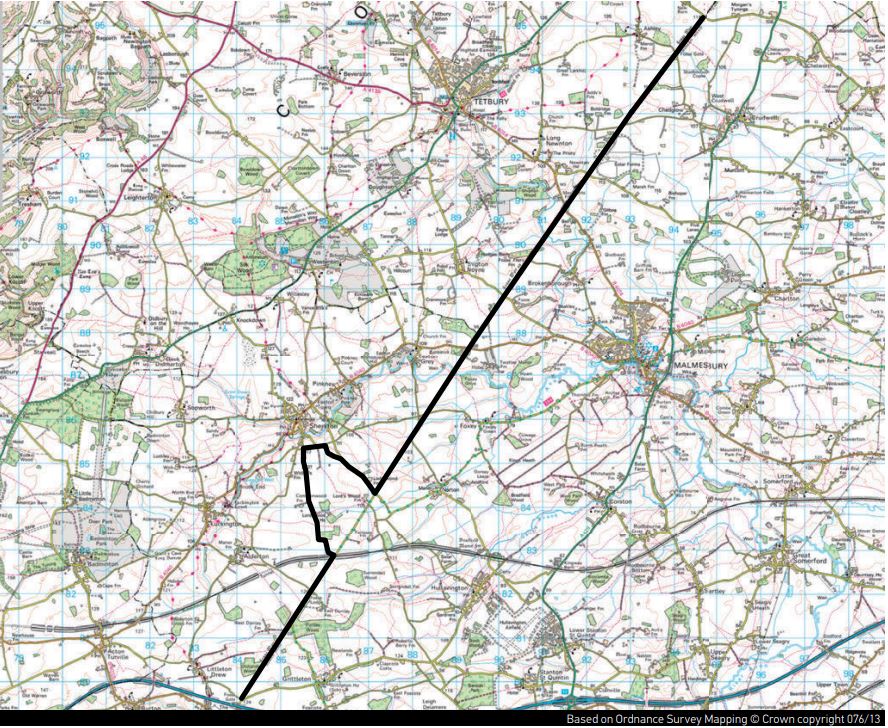
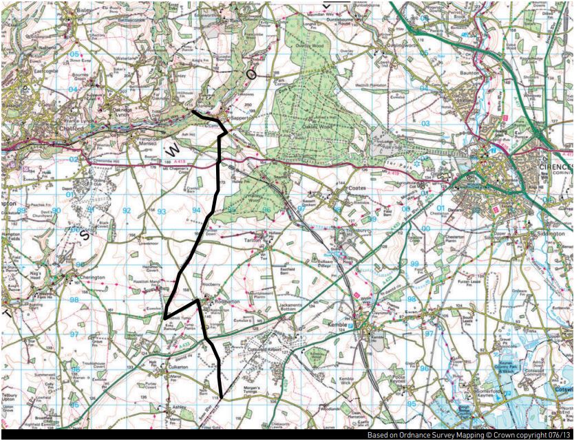
The present-day Fosse Way takes many forms – sometimes it has been incorporated into major roads, sometimes county or parish borders and, more importantly for adventure bike riders, sometimes it’s an extremely enjoyable and accessible byway through stunning parts of Great Britain. The two sections of the Fosse Way we’re covering in this issue are firstly from Littleton Drew to Kemble Airfield, and then from Kemble up to Sapperton, conveniently finishing at the recently refurbished and now rather agreeable Daneway Pub. The whole route should take about two hours.
1-2
So, the first part of our route starts just outside Littleton Drew. If you need a meeting point for your mates, The Salutation Inn on the B4039 in a village called The Gibb will work well. From here, go under the motorway bridge and after a few hundred metres there’s a junction with the road coming from Littleton Drew on your left. The road you are on continues round to the right, and ahead of you, this section of the Fosse Way starts to the right of a Cotswold stone house.
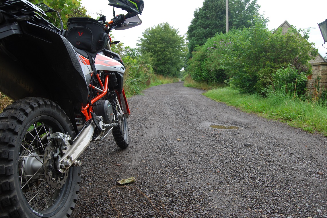
Ideally, don’t hang around outside the house and irritate the residents, just set off onto the trail! The surface is very good as, in general, the Fosse Way is well maintained by Wiltshire County Council, so it’s fine gravel without too many big holes or dips. But just because it’s straight and relatively easy to ride, don’t go mad. As with all byways, it’s shared use and you can meet horses, walkers, cyclists and 4x4s, so enjoy the view rather than trying to hit sixth! This section continues for just about a mile, dropping down towards the end to join a tarmac section leading into a house on your left, but you go straight on to join the main road on a bend.
2-3
Emerging onto the road, you travel straight (something you’ll be doing a lot on the Fosse Way) for another mile or so passing through a crossroads to East Dunley and Luckington. At 2.4 miles you will cross a railway line, and just after there is a left turn onto another byway. This part is not actually the Fosse Way, so you can just go straight to pick up the next section, but it’s a shame to drive past as it’s a good little lane. Follow it through the woods and on to the end at 3.3 miles and ride onto the road ahead until you come to a crossroad at 4.2 miles, where you turn right, continuing on and taking another right shortly after.
The road sweeps through left and right and will eventually bring you to the next section of the Fosse Way at Ladyswood at 5.6 miles – if you missed out the little diversion you will have arrived here already. Turn left onto the trail – the track is nice and wide here, so you can see what’s ahead, which means that you can turn up the wick a bit and blast through the puddles. After half a mile or so you join the road for a 100m and then your route forks off to the right into the trees at 6.7 miles.
3-4
Now the trail gets a bit muddy and more technical, so if you are on road-biased tyres, a big bike or indeed both, then a bit of care may be called for. The lane is tighter here and in summer there’s a fair bit of vegetation to contend with, but it’s quite a short section and you meet the road at 7 miles.
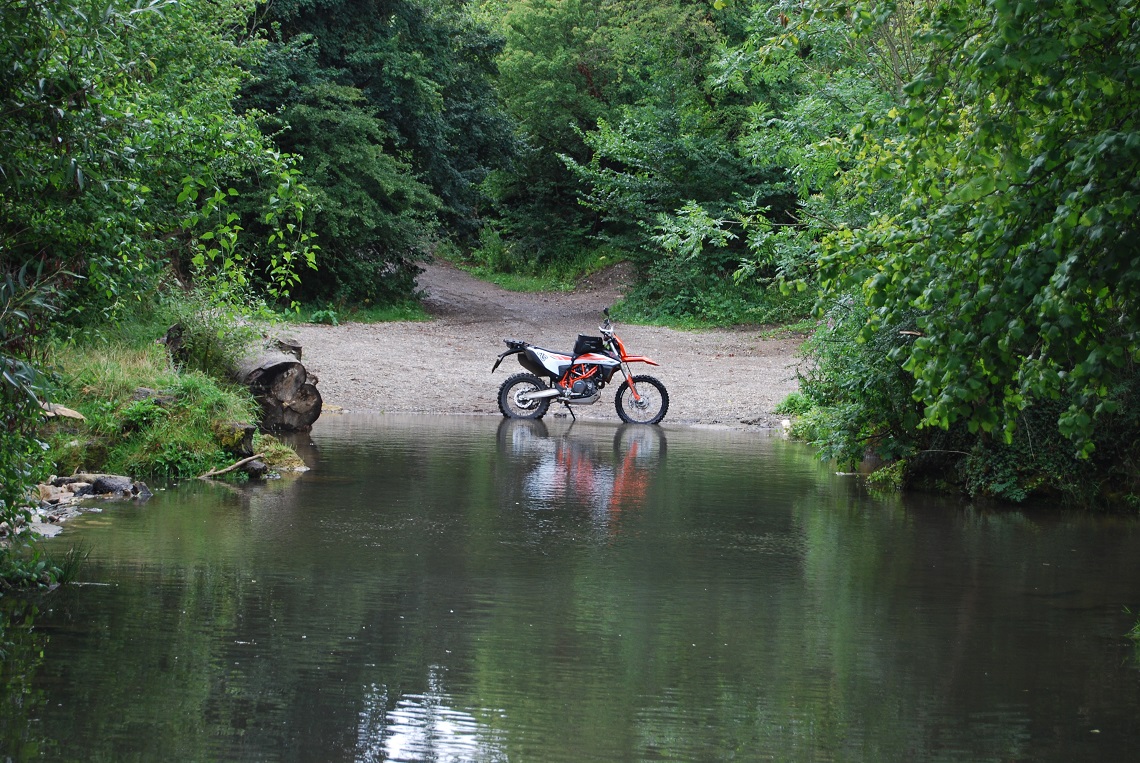
The next bit is the only part of this stretch of the Fosse Way that is closed to four-wheeled traffic – the reason for the restriction is that after a short distance (at 7.6 miles) the route drops down to the River Avon and over the years this became an extremely popular playground for 4x4s and bikes to crash in and out of the water. Inconveniently, the area is also the site of the Roman town of Easton Grey, and the activity was wrecking what was left of the remains, not to mention doing little for the local wildlife.
Now free from the grind of differentials and with the river fenced off, it’s a great place to stop for a breather and enjoy the view. Suitably refreshed, remount and follow the trail up the hill to join a tarmac section at 8 miles that leads to the road. Keeping straight across, there are now two more uncomplicated and winding sections, crossing the road at 9 miles past Fosse Cottages and continuing up until, at 9.7 miles, the road goes to the right, but the Fosse Way continues straight.
4-5
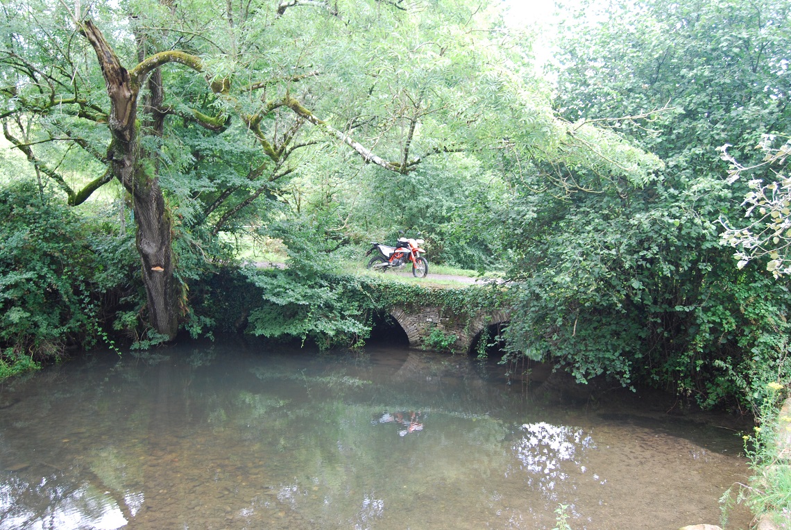
The trail continues and drops through the trees and it’s rather beautiful here, but be careful of low branches and the odd root to catch you out. When the odometer clicks to 10.2 the Tetbury branch of the River Avon is in front of you. It is passable and, if you are a confident rider, by all means, have a go, but stop to assess the depth before you go plunging in as it gets very deep in winter!
For those less brave, or indeed more sensible, there is an ancient bridge to the left which will take you over the water, but take care where it drops down to the trail again as the bank is quite soft. With or without wet feet, continue away from the river and follow the trail north-east up to meet the road at 10.7 miles, passing over for more of the same for another half a mile, crossing again at 11.3 miles. Here, the trail forks and you need to go left rather than through the farm if you go right.
There are a lot of horses in this area, which you can see and probably smell, so keep it slow as you pass through and cross over three separate farm tracks. You will meet a road again at 12.2 miles, but you quickly peel off to re-join the Fosse Way again, and there’s another road crossing at 13.5, which requires 50m or so on the road to reach the trail once more.
5-6
Distance: 14.2 Miles
Nearest Town: Chippenham – 7.3 miles
Maps: Start/End grid reference: ST841795 / ST946952
Difficulty Rating: 2
Wow Factor: 3
Other Trails Plenty in the area and UK TET uses some of this route
So, we’re nearly done now and with quite so many miles of straight and flowing trails, it should have given you plenty of time to get the feel of your bike and see how it handles away from the blacktop. The final section before you reach Kemble Airfield is just under a mile of great trail ending in another road. Your whole route will have taken you 14.2 miles and probably just under an hour with a few stops. If you’ve had enough, a left turn will take you through Culkerton and on the A433 to get you home. If you are up for more, you can turn 180 degrees and head back the way you came. Or maybe take on the second part of the Fosse Way ride…
Kemble to Sapperton
OK, so although the next part is still the Fosse Way and although still pretty straight, it’s far more challenging to ride. And the reason for this is simply one word – ruts. Riding ruts requires a balance of both confidence and self-belief at the best of times, but throw in the added challenges of heavy bikes, dual sport tyres and a healthy dollop of overhanging vegetation on both sides of the trail, and this unassuming five-mile stretch of riding can have you swearing like a docker within seconds.
We only came to grief once while preparing this route, but it was more of a gentle slide to the left rather than anything more dramatic thanks to relatively low speeds. There are some lovely tight and twisty sections here, and slicing through the Gloucestershire countryside on a motorcycle is a great way to spend the day. If you needed any more persuasion, we’ve even ended the route at a pub – are we good to you or what?
Please be aware that if you take on this section on a big adventure bike it’s going to be quite hard work and, once you start, there are not that many opportunities within each section to turn around if you are not enjoying it much! You have been warned.
1-2
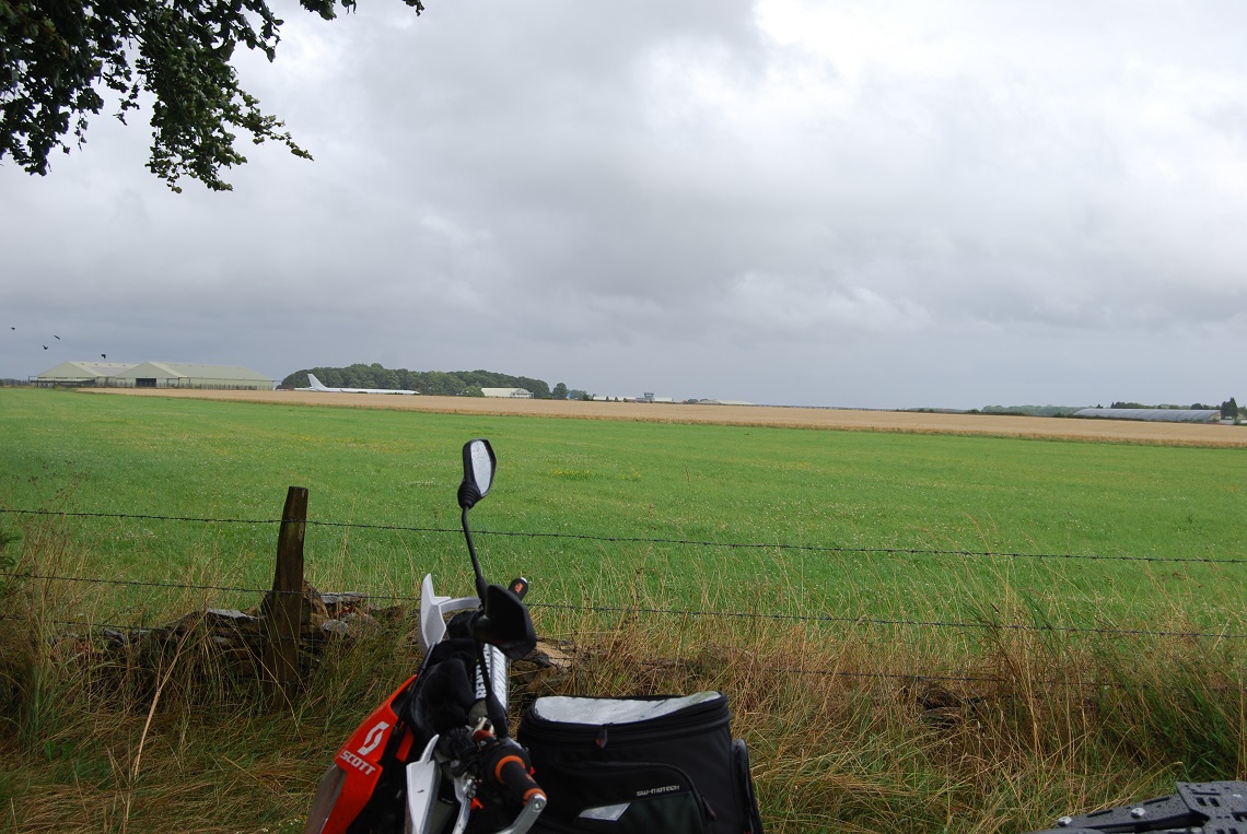
Starting from the bottom end of Kemble Airfield, we are first going to cross over a field. There is a very clearly marked track that we need to follow, so don’t be tempted to ride anywhere else. Open the gate, get yourself through and shut it behind – countryside code and all that! Follow the track up the field for half a mile or so and then it sweeps round to the left towards some farm buildings, before returning to the top right-hand edge of the field. Follow the track up to the second gate by the wall.
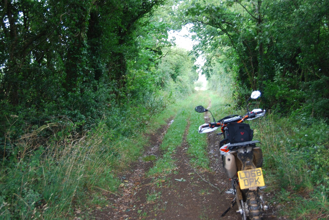
Go through this the same way as before and there’s another gate after another 100m of grassy ruts, so if there’s a few of you then send someone up to the next gate while you close that one. Over on your right, you can see the planes at Kemble Airfield. The next gate will take you back into a lane with more of those lovely ruts. Choosing which one is tricky; the side ones are wider, but you have to fight the branches, while the centre is less obstructed but often narrower as it’s only bikes that have been there, and if you wobble your foot usual slips down into the outer ruts!.
However you do it, follow the trail and the ruts for another mile or so until you the track opens up and you drop down through the brickwork of a disused railway bridge to meet the last gate before you come to the A433 with Tetbury to your left and Cirencester to your right at 1.1 miles. Take a breather – you’ve earned it!
2-3
Cross the road and head towards Rodmarton, passing Rodmarton Farm and continuing all the way up to the first left turn towards Hazelton and Cherrington. Follow this road down to the fork junction, where you can pick up the Fosse Way again at 2.5 miles. It’s easy to miss the turning, but it’s a small entry into the lane on the right. This lane is thankfully fairly rut-free and there are often some great puddles to blast through, but just keep an eye out for walkers and cyclists.
After a wooded section, the lane passes into more open country, but with bushes and trees lining the route it still needs some concentration. The route sweeps from left to right and there are a few rutty corners and low branches to catch you out even on a smaller bike. At 3.4 miles you cross over a small road for more of the same on tight and twisty lanes. With quite so much vegetation, any hope of keeping those plastics scratch-free need to have long gone, but hell, it’s an adventure bike! Press on up the trail until you cross another road at 4 miles, entering on a bend, after just 50m it’s back on the trail all the way to 4.5 miles and then you need to stop.
3-4
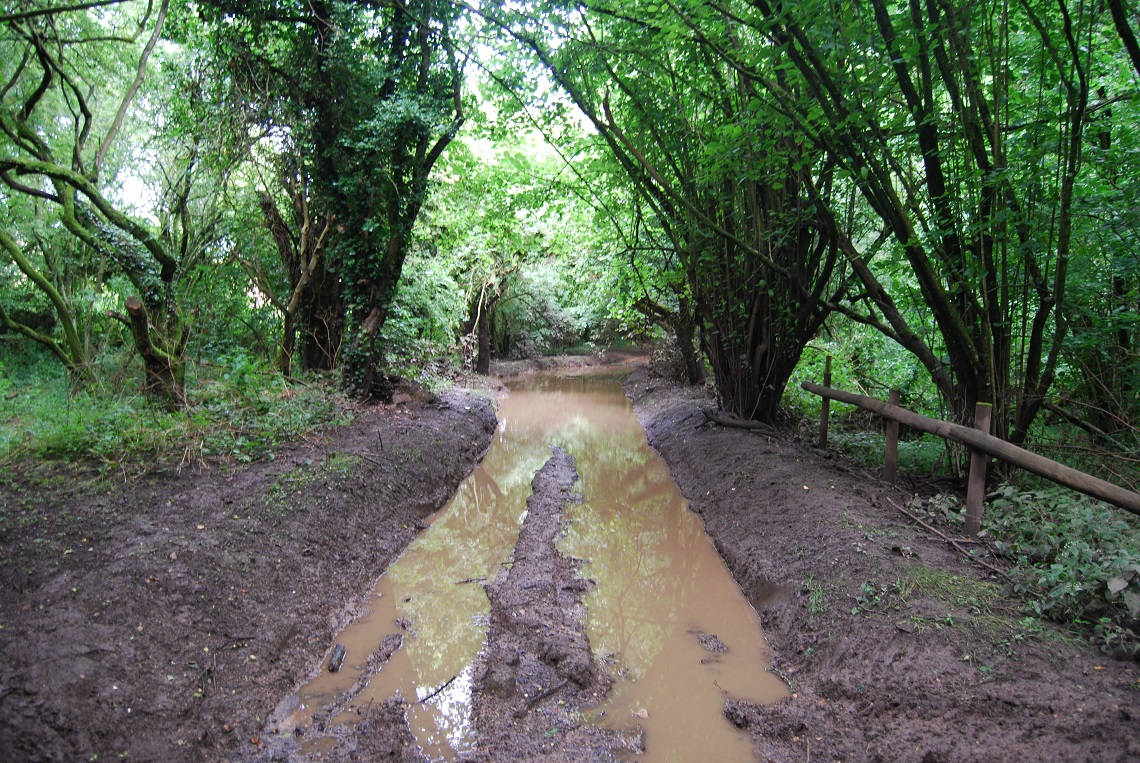
So, at this point in the Fosse Way, there is a really deep and muddy puddle. There’s a hard surface underneath and it’s quite achievable to ride through, but your initial reaction will probably be: ‘Sod that!’. But it’s OK, look ahead, don’t enter too quickly, keep your revs up, cover the clutch and, crucially, don’t change sides halfway through unless you like getting really muddy!
There is evidence that other explorers, whether walkers, mountain bikers or even motorcyclists, have taken a route into the trees on the right, but clearly we can’t condone this, so ride through the mud and make sure your mates are on hand to laugh, photograph and then eventually help if things go wrong. Once out of the mud, the trail is really quite tight again and the central rut is the only option to avoid the greenery and make progress – it really needs a farmer with a hedge cutter to go through this lane to clear a path. Things eventually open up after half a mile or so and the trail drops down to the A419 between Brimscombe and Cirencester at 5.6 miles. Nearly done!
4-5
Distance: 7.1 Miles
Nearest Town: Cirencester
Maps: Explorer 168
Start/End Grid reference: ST 946 952 / SO 938 034
Difficulty Rating: 4
Wow Factor: 4
Other Trails: Plenty in the area and some real beauties.
We are on the final stretch now, but be careful here as it’s a fast road. You go right for 20m and then re-join the trail as it climbs up into more woods. As you drop down from the high point there are two big puddles and, ideally, you should cross them on the right as they are shallowest there. You really don’t want to drown your motor so close to the end. After that, there’s nothing more to worry about as you complete the final trail section to bring you to the road at 6.1 miles.
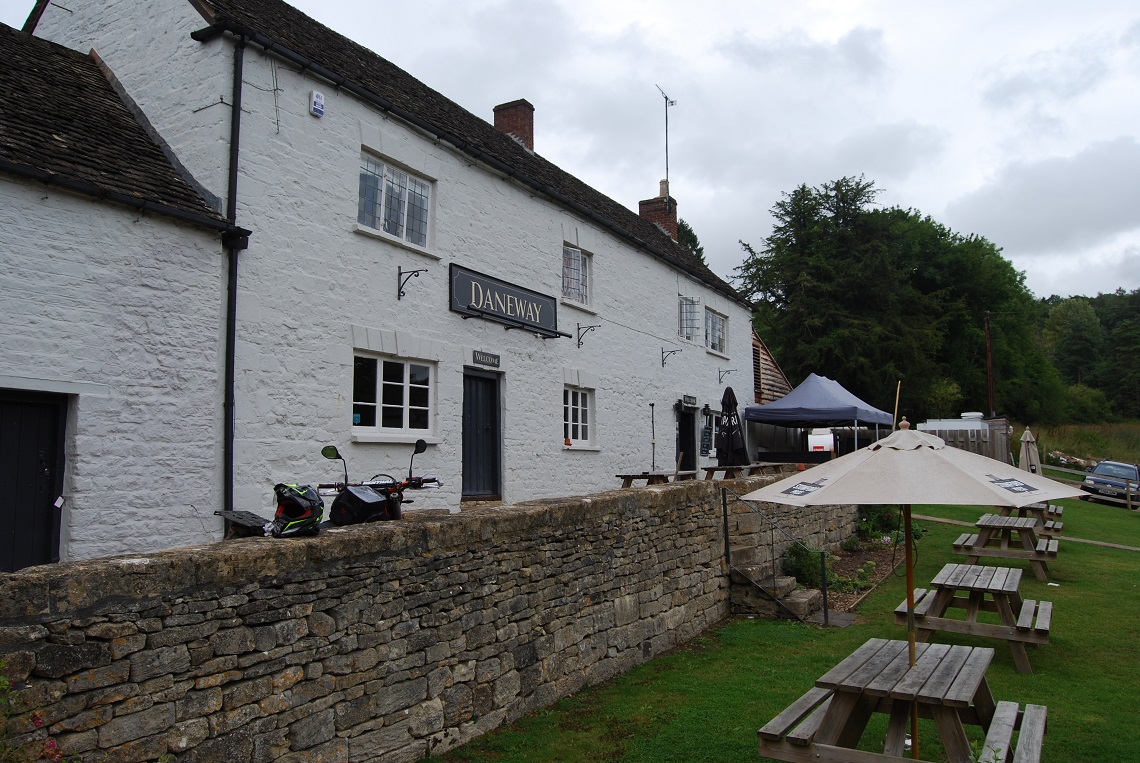
Turn right and then take the next left towards Edgeworth and Bisley, passing through the tiny village of Sapperton and following the road down the hill. At the bottom, The Daneway pub is your endpoint and a cooling beverage awaits. Perfect. While you enjoy the drink, you now need to decide whether you have had enough or want to retrace the whole route on the way back. Or maybe you could investigate that trail you just passed before the pub – that one’s a corker!