

This issue: Sedgefield, Country Durham and Botallack Mine, Cornwall

Sedgefield, County Durham
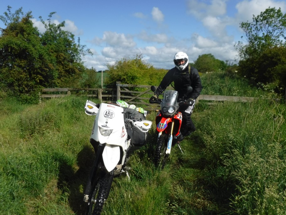
It had been six months since my last ride so I was pleased when coronavirus restrictions were eased and I managed to enjoy a social-distanced weekend riding with a good friend. He lives in Durham so this would be our starting point. Just a few miles south of the city lies what he says is the best lane in the area. It’s located close to junction 60 of the A1, so is easily accessible for anyone venturing this way.
I have to admit to being quite shaky on this trail. It’s amazing how a lengthy period off the bike can knock your confidence. The lane, located near Sedgefield, is very rutted and muddy in places. Be aware the lane is subject to a winter voluntary traffic regulation order (VTRO) which asks people on motorcycles and in 4x4s to bypass it in winter, particularly in wet conditions, to help preserve the lane.
The route
1-2
If turning right into the lane, take care as you will cross four lanes of traffic. The lane is a car’s width wide and hard compacted as it leads towards Neasless Farm. There are a few puddles and the surface is loose in places. At the bend, take the left (straight on) track, as the right will only take you to the farm.

Watch out for farm animals
2-3
The track changes here as it passes beneath the trees. It’s narrower with grass growing in the middle but still a solid base to ride on. Continue round a sharp right then left bend. Pass through the gate, and there is a sign stating the VTRO.
3-4
The lane changes once again. It is now overgrown and very rutted. It has a grassy, muddy base, and keep an eye out for the ruts. If it’s raining, it can get very slippery in the wet. Pass through another gate. The trail opens up a bit now as there are open fields to the right but be careful as the ditch on the right is full of water. When overgrown, it’s not easy to see.

The trail becomes overgrown
4-5
There are still three rutted lines, the common four-wheel-drive tracks, and the standard motorbike track in the middle. The going now becomes tougher in places with deep muddy ruts, so take care. It’s not easy to jump the ruts if you need to, so choose your route carefully.
5-6
Proceed through another gate. You almost loose the track now as it’s so overgrown. It gets a lot worse with lots of deep mud and ruts. Go through another gate and onto a solid base. I’ve got to admit to sweating a lot by now, but there’s easier riding ahead.

Always close gates behind you
6-7
The track heads right to the farm. Proceed through a gate and the track becomes overgrown again. Head beneath the trees as the track narrows. Continue onto the next gate and then onto another at the end of this green lane where you meet the tarmac.
The facts:
| Distance: | 2.5 miles |
| Nearest Town: | Sedgefield |
| Maps: | Middlesbrough, OS Landranger 93
Start/End grid reference: NZ366278 / NZ380243 |
| Difficulty Rating: | 3 |
| Wow factor: | 2 |
| Other trails: | Slaley Forest is about a 25minutes ride away. See ABR issue 45. |
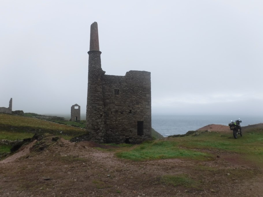
Botallack Mine, Cornwall
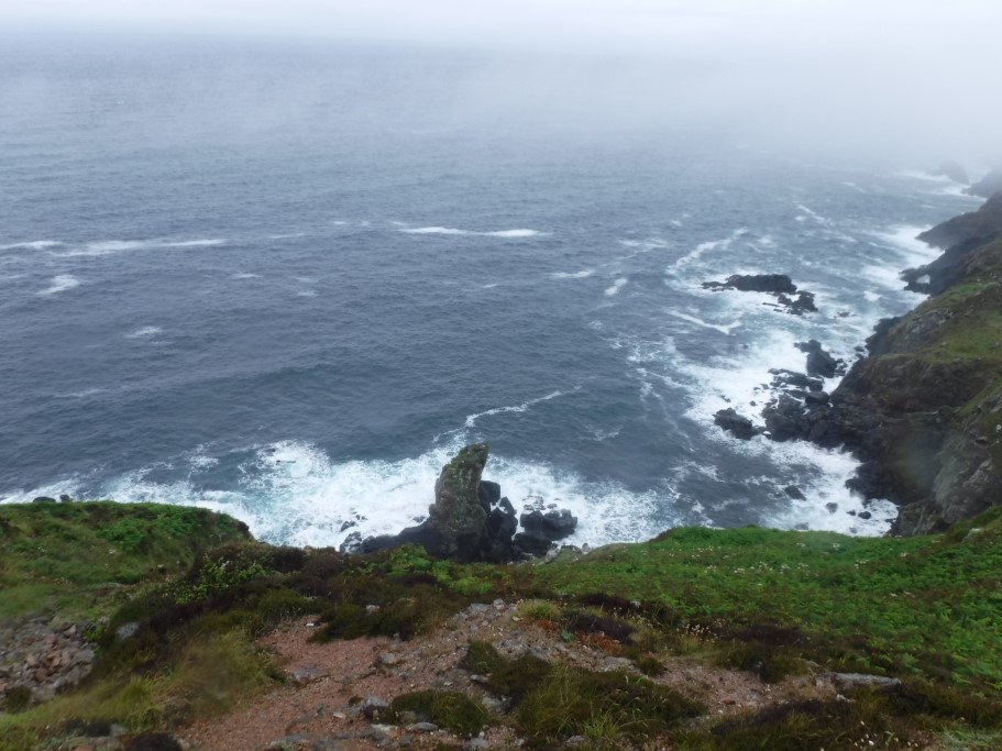
As a small boy, I remember my grandparents had a painting on their wall of some Cornish tin mines. I’d also previously seen photos of the tin mines on various Trans Euro Trail chat forums but this was my time to see them for real, and I wasn’t disappointed.
Seeing the tin mine ruins come into view on a misty morning will stay with me for the rest of my life. I pulled over, brewed up, and spent an hour wandering among the ruins. The Atlantic Ocean crashing against the rocks below was a magnificent sight.
Its trail itself is fairly straightforward and can be ridden on a bigger adventure with any tyres in the dry, apart from section 1-2 which requires decent offroad rubber. I enjoyed my ride on the trail so much, I turned right around and did it again for a second time.
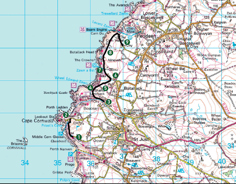
The Route
1-2
Ride along a tarmac single-track road, passing a bronze age burial ground on the left which is worth a quick stop. The off-road track is obvious and starts as you ride between concrete pillars. There should be a fantastic sea view to the left but unfortunately for me I rode on an overcast and rainy day. There are plenty of loose rocks to bounce over so take care as you proceed downhill, but it’s nothing too technical. There’s a large stone wall to the right with a golf course behind. This section ends at Cape Cornwall which is a good location to stop and take some photos.

Sea mist rolls in
2-3
A tarmac section.
3-4
When the track begins, you soon pass a turning on the left (gated) but continue straight on. The track is wide and easy. It consists of a hard-compacted base with only a few small stones and occasional puddles. Pass another turning to the left but keep going. You pass a further turning to the left which is signposted National Trust. Keep heading straight on proceeding uphill along the legal byway. Towards the top there are turnings right and left. Just keep heading straight. The route is pretty obvious.

The trail widens
4-5
As you crest the top of the hill, the first of the tin mine ruins comes into view, and the second follows a short distance ahead. It really is dramatic scenery. I spent an hour wandering between these two ruins soaking up their history. As you pass the first tin mine, stay on the higher track, the one heading left is a footpath only. Again, the track hasn’t changed. It’s very easy going and fairly wide. It shouldn’t trouble anyone and could even be attempted with road tyres if care is taken.
5-6
The track now heads inland and, despite a few turnings off the main byway, is fairly obvious.
6-7
At the T-junction, turn left. Again, ignore the many turn-offs and stick to the main graded track. You pass a couple of houses on the right and please take care here as they are residential. As you pass some ruins on the right, the workings of Botallack Mine comes into view. This is private property so don’t go exploring. There are more mine workings off to the left as you proceed slightly downhill.
7-8
Pass a house on the right and head downhill through a dip. Stay to the right for the easiest approach up the next hill. This is probably the hardest section on the trail so, if you are unsure or using road tyres, maybe it’s worth missing out. However, make sure you take a look as there’s plenty of space to turn a bike round for the duration of this trail.
A Botallack mine ruin
8-9
The three Levent Mine ruins (I say ruins, they look pretty spectacular to me) come into view. Turn right at the carpark and continue along the trail to the tarmac, passing another ruin on the left. If you have the time, be sure to stop and enjoy a tour around the mines to find out about this area of Cornwall’s rich history.
The facts:
| Distance: | 4.5 miles |
| Nearest Town: | St Just |
| Maps: | Explorer 102, Land’s End
Start/End grid reference: W354212 / SW374340 |
| Difficulty Rating: | 2 |
| Wow factor: | 5 |
| Other trails: | Cornwall has limited green lanes but check out the Great Western Trail section of the Trans Euro Trail |
