Ok guys after a bit of help here,few of us are planning on doing the lgks this year and im struggling to find a map on garmins website for it,do i need a map for italy or france or both and would the topo map be best ?
thanks in advance
Ligurian Border Ridge Road what map for garmin
Re: Ligurian Border Ridge Road what map for garmin
Never done it..but Boboneleg or stan may have ..there is a thread on adv..just google the route...
as for maps if the trail is visible in google earth then do a track and export as gpx..all depends which country its in most france or italy...
I use the france topo and its good at showing trails and dirt tracks with altitude too..never used the italian one...but the maps can be got off ioffer..
looks a nice challenging ride on a big bike...but I dont particularly like italy..personnel thing..
-
boboneleg

- Posts: 5208
- Joined: Tue Sep 13, 2011 5:52 pm
- Has thanked: 2363 times
- Been thanked: 1407 times
Re: Ligurian Border Ridge Road what map for garmin
One of the best trails I've ridden but I am a dinosaur so I use paper maps 

one-legged adventurer
Re: Ligurian Border Ridge Road what map for garmin
I'm a maps person too, so that makes two dinosoars !boboneleg wrote:One of the best trails I've ridden but I am a dinosaur so I use paper maps
Re: Ligurian Border Ridge Road what map for garmin
Bob's got the map numbers but you can get them from Stanfordsbond_yzf wrote:what maps and where did you get the from guys ?
I've just got some Pyernees OS maps at 40 and 50,000 - dealt woth Elizabeth - very helpful and quick - they came the next day
-
Stormforce8
- Posts: 49
- Joined: Thu Oct 07, 2010 9:50 pm
Re: Ligurian Border Ridge Road what map for garmin
Agree with Bob on this, one of the best trails I've ever done - paper maps are the way to go - and makes the planning and riding more enjoyable (well it did for me  )
)
The maps you want are the IGC Walking maps (Istituto Geografico Centrale) available from Stanfords - IIRC you'll want #7, #8, #14, & possibly #24


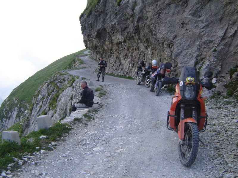
Quite a few interesting choices on getting up onto the ridge - this one's fun :laugh:

The maps you want are the IGC Walking maps (Istituto Geografico Centrale) available from Stanfords - IIRC you'll want #7, #8, #14, & possibly #24
Quite a few interesting choices on getting up onto the ridge - this one's fun :laugh:
Re: Ligurian Border Ridge Road what map for garmin
if you have the route just change it to a track in basecamp then select offroad mode on montana..even with basic citynavigator it will show as a overlay easy to follow..bond_yzf wrote:i have the route downloaded from alpenrouten and saved as a gpx just need the correct mapping for the montana
But seeing as its in italy and the pic from stormforce B) I`d get the italian garmin topo map..cant be more than £25..it will show all those mountain gravel trails for sure..
But it would do no harm to have a map for back up..you should be able to load the gpx file into google earth and fly the whole route. :laugh:
Re: Ligurian Border Ridge Road what map for garmin
Now that route upto the ridge does look very interesting,I think we are in for a Good time in July.Stormforce8 wrote:Agree with Bob on this, one of the best trails I've ever done - paper maps are the way to go - and makes the planning and riding more enjoyable (well it did for me
The maps you want are the IGC Walking maps (Istituto Geografico Centrale) available from Stanfords - IIRC you'll want #7, #8, #14, & possibly #24
Quite a few interesting choices on getting up onto the ridge - this one's fun :laugh:
Stella Alpina,Jafferau and the Lgks.
2011 Yamaha XT660Z Tenere
