EDC Trans Pyrénées Trail, reconnaissance.

Where you've been and what you done
User avatar
WIBO
Posts: 1598
Joined: Sat Sep 22, 2012 3:37 pm
Location: French Pyrénées
Has thanked: 612 times
Been thanked: 648 times

Re: EDC Trans Pyrénées Trail, reconnaissance.

Post by WIBO »

Double checked......all regular Simon.

Any points I mark are marked real time when I stop and then note and edit waypoint as to what it'll be, i.e. start of piste, sign, pond etc. before riding on.

Can you double check too in case I'm missing something? Are you actually entering the co ordinates into a GPS to check?....... or using some other method?

:D
Last edited by WIBO on Fri Feb 02, 2018 11:42 am, edited 2 times in total.
Will It Buff Out?
User avatar
WIBO
Posts: 1598
Joined: Sat Sep 22, 2012 3:37 pm
Location: French Pyrénées
Has thanked: 612 times
Been thanked: 648 times

Re: EDC Trans Pyrénées Trail, reconnaissance.

Post by WIBO »

PHILinFRANCE wrote: Wed Jan 31, 2018 11:17 am I always carry one of these Keith , quick fix and gets you home
https://i.ebayimg.com/images/g/P5kAAOSw ... s-l500.jpg
But Phil.......that's too sensible........ I'm surprised at you!

:lol: :lol: :lol:
Will It Buff Out?
User avatar
WIBO
Posts: 1598
Joined: Sat Sep 22, 2012 3:37 pm
Location: French Pyrénées
Has thanked: 612 times
Been thanked: 648 times

Re: EDC Trans Pyrénées Trail, reconnaissance.

Post by WIBO »

minkyhead wrote: Fri Feb 02, 2018 10:22 am seen some action that rim keith ... great pictures thanks for posting 8-)
Same scars every puncture!!.........but hey......it's only a rim on a motorbike.


:D
Will It Buff Out?
Neil M
Posts: 194
Joined: Mon Dec 19, 2011 9:30 am
Has thanked: 30 times
Been thanked: 32 times

Re: EDC Trans Pyrénées Trail, reconnaissance.

Post by Neil M »

Regarding the GPS points, it seems to be what happens when you just cut and paste the co-ordinates into Google maps, you end up in the Atlantic!

You end up in the right place if typed into a GPS system and what a great place it is!

:)
User avatar
WIBO
Posts: 1598
Joined: Sat Sep 22, 2012 3:37 pm
Location: French Pyrénées
Has thanked: 612 times
Been thanked: 648 times

Re: EDC Trans Pyrénées Trail, reconnaissance.

Post by WIBO »

Yip......google uses a goofy set up when presented with proper co-ordinates...


I thought it might've been that. Simon can advise if he did that too.

:D
Will It Buff Out?
Simon_100
Posts: 7366
Joined: Fri Apr 08, 2011 12:02 pm
Has thanked: 44 times
Been thanked: 112 times

Re: EDC Trans Pyrénées Trail, reconnaissance.

Post by Simon_100 »

WIBO wrote: Fri Feb 02, 2018 11:38 am Yip......google uses a goofy set up when presented with proper co-ordinates...


I thought it might've been that. Simon can advise if he did that too.

:D
Curiouser and curiouser, I tried juts typing them into Google Maps and need up west of Madrid - not far from where a good friend is laid up in hospital - WIERD! - but I also checked the junction of the HU-212 on Basecamp and that doesn't seem anywhere near either ...

Image

As well as the WP take a peek at the co-ords on the grid lines too!

Regs

Simon

PS playing around - I delete the first two '0's on the westing and went to a place near Fatima in Portugal, which has some sort of logic I suppose. But then I typed them back in again and found myself way up north at Santiago de Compostela - sort of due north of Fatima ... bot of them important pilgrim sites! WIERD!!!
Be sure to visit www.thespanishbiker.com the invaluable guide to motorcycling in Spain - plus guided rides, HISS Events* and off road touring support service


*Highly Informal Sojourns in Spain
User avatar
WIBO
Posts: 1598
Joined: Sat Sep 22, 2012 3:37 pm
Location: French Pyrénées
Has thanked: 612 times
Been thanked: 648 times

Re: EDC Trans Pyrénées Trail, reconnaissance.

Post by WIBO »

:D :D :D :D

A bug in your system possibly or more likely .......

....and to highlight, a lot of people simply don't know, as I did not also before, that Google Maps are goofy when presented with real world GPS coordinates.... ...so hopefully the info below can assist you and others in the future and to be aware when using Google instead of an actual GPS or Basecamp etc. to confirm where you need to be...one could get caught out easily if not versed in this?


The first point I listed Simon....


'We pick up the trail at Arette'

N 42 35 053
W 000 34 545


If you the follow the link below to use normal GPS coordinates with the Google Map software system.


After that Simon, you enter the coordinates and click on ' convert and map '

http://boulter.com/gps/


You can see it converts to show the waypoint as noted on the actual GPS at the time.


Screen Shot 2018-02-02 at 13.24.24.jpg
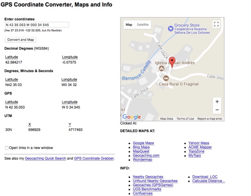
Screen Shot 2018-02-02 at 13.24.24.jpg (105.21 KiB) Viewed 3068 times


As you can see Simon, in the satelite image at the bottom of the thread, the trail starts in a small gravel turning circle, with a car parked there at 3 o'clock,( that corresponds when I double check my GPS screen after entering the coordinates into same )


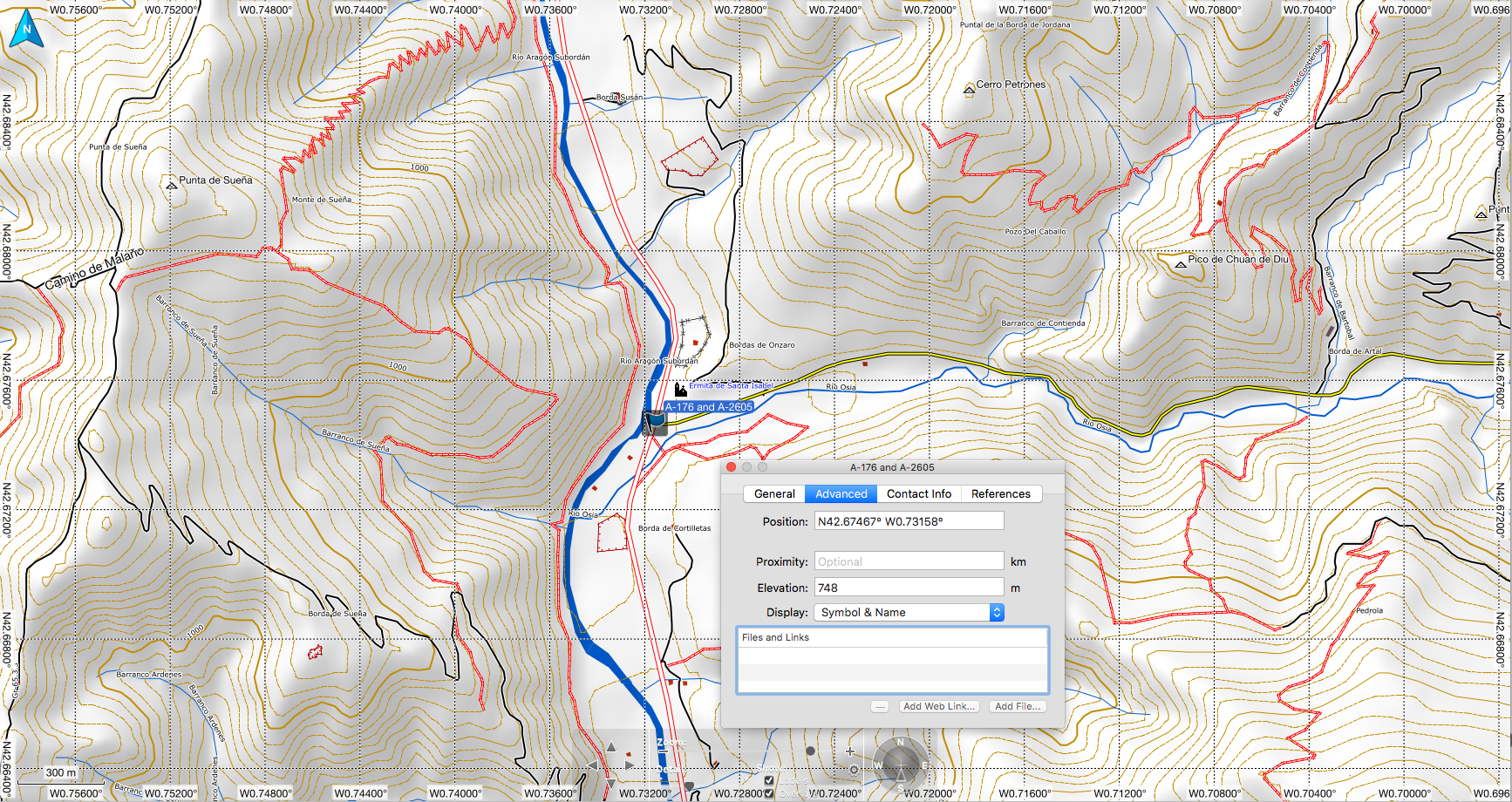
To recap Simon, it's always better to enter the coordinates into an actual GPS and zoom out and in and to have a wee peep at the map in it , rather than to trust Mr Google Maps ......or you will indeed end up in the likes of the Atlantic paddling your moto or find yourself in Madrid when you should'nt be there !!! :)

I hope this helps you and others in the future.


:)


.
Attachments
Screen Shot 2018-02-02 at 13.25.52.jpg
Screen Shot 2018-02-02 at 13.25.52.jpg (129.04 KiB) Viewed 3068 times
Will It Buff Out?
aliwakeskate
Posts: 498
Joined: Fri Dec 02, 2011 9:18 pm
Location: Birmingham
Has thanked: 268 times
Been thanked: 171 times

Re: EDC Trans Pyrénées Trail, reconnaissance.

Post by aliwakeskate »

Nice one Keith. Some very useful info for anyone heading over the pyrenees for a bit of off roading! The routes on wikiloc are very usefu also.

For info, those co-ordinates worked on my GPS and basecamp - I never use google maps for gps co-ords as it can be a pain to input the figures correctly and needs a bit of knowledge on how to.

However, for those that want to use google maps you need to input the co-ords with degrees and minutes symbols e.g.:

Wibos co-ords for Arette:
N 42 35 053
W 000 34 545

Convert these yourself to 42°35'05.3"N 000°34'54.5"W and these will show in google maps. If you do this, you can see the pin just south of a track.

Great stuff Keith, keep it coming!
Simon_100
Posts: 7366
Joined: Fri Apr 08, 2011 12:02 pm
Has thanked: 44 times
Been thanked: 112 times

Re: EDC Trans Pyrénées Trail, reconnaissance.

Post by Simon_100 »

Nice work guys!

Simon
Be sure to visit www.thespanishbiker.com the invaluable guide to motorcycling in Spain - plus guided rides, HISS Events* and off road touring support service


*Highly Informal Sojourns in Spain
Moo
Posts: 78
Joined: Wed Jan 31, 2018 7:30 pm
Location: United Kingdom
Has thanked: 3 times
Been thanked: 5 times

Re: EDC Trans Pyrénées Trail, reconnaissance.

Post by Moo »

Those trails look great! Thanks for posting!
Post Reply

Return to “RIDE REPORTS”