Possible week in France and ...

The black art of moving from A to B on foreign soil
Onenoodles
Posts: 79
Joined: Sun Mar 28, 2021 6:37 pm
Location: Worcester
Has thanked: 1 time
Been thanked: 53 times

Possible week in France and ...

Post by Onenoodles »

going on my XT660Z, I would like to take in some off-road trails / forest tracks etc ... nothing too gnarly, easy to moderate and nice views, preferably hilly / mountains.
I would be keeping the costs down and mostly camping (sites or a bit of stealthy stuff) ... don't mind sticking it on a motorway first day to get some miles in if needed .... so, anyone got any ideas on areas to head for please?
I know I can get info of the TET site but I am a bit of a techno phobe and prefer maps or head somewhere on my basic sat nav then pick a trail / track up like that ... GPX files and stuff just seems to confuse the heck out of me :D

Done loads of touring in France Spain in the past but all road stuff ... just want to get away from all that for a few days.

Any advice welcome :)

Cheers

Noodles
bikenav
Posts: 1277
Joined: Mon Jan 28, 2013 11:46 pm
Location: Llanelli
Has thanked: 1187 times
Been thanked: 761 times

Re: Possible week in France and ...

Post by bikenav »

I have only a little experience really of trailriding/finding in France there will be others with far more knowledge, As I am sure you know the proper lumpy bits of the country are a few hours even via autoroute from the boats. For myself if in rural areas as long as not totally flat on the trails, I need not be in the mountains, in actuall fact trailriding in mountains makes things a lot more complicated, they are often some kind of park with much reduced access one way or another, far fewer trail or even road options, increased difficulty/risk. Using a paper map is no problem to me done thousands of miles in Euro and beyond with maps in mapcases strapped on the tank on road based trips. To use paper maps to find trails in France if at all possible imagine the scale needed, the number of maps, availability, cost , weight and volume, I am unsure if it is possible at all and pretty sure impractical unless you wanted to confine yourself in one area. As a basic GPS user even if you just use it as a waterproof map that is always on the right page in the right place at the right time showing detailed information down to trail level or not in one plastic box in front of you, in its most basic use thats all it has to be .
The important point of the GPS is that you are using the right map loaded on it, just as if you were buying a paper map different maps show different features/detail. Not all GPS units allow the use of different maps, some will allow more than one and you can switch between them to suite what info you want to see, it all is a bit of a side skill like maintenance, paper map navi, camping or whatever else that goes in to motorbike touring.
Not sure I am being really helpfull but thats my take anyway.
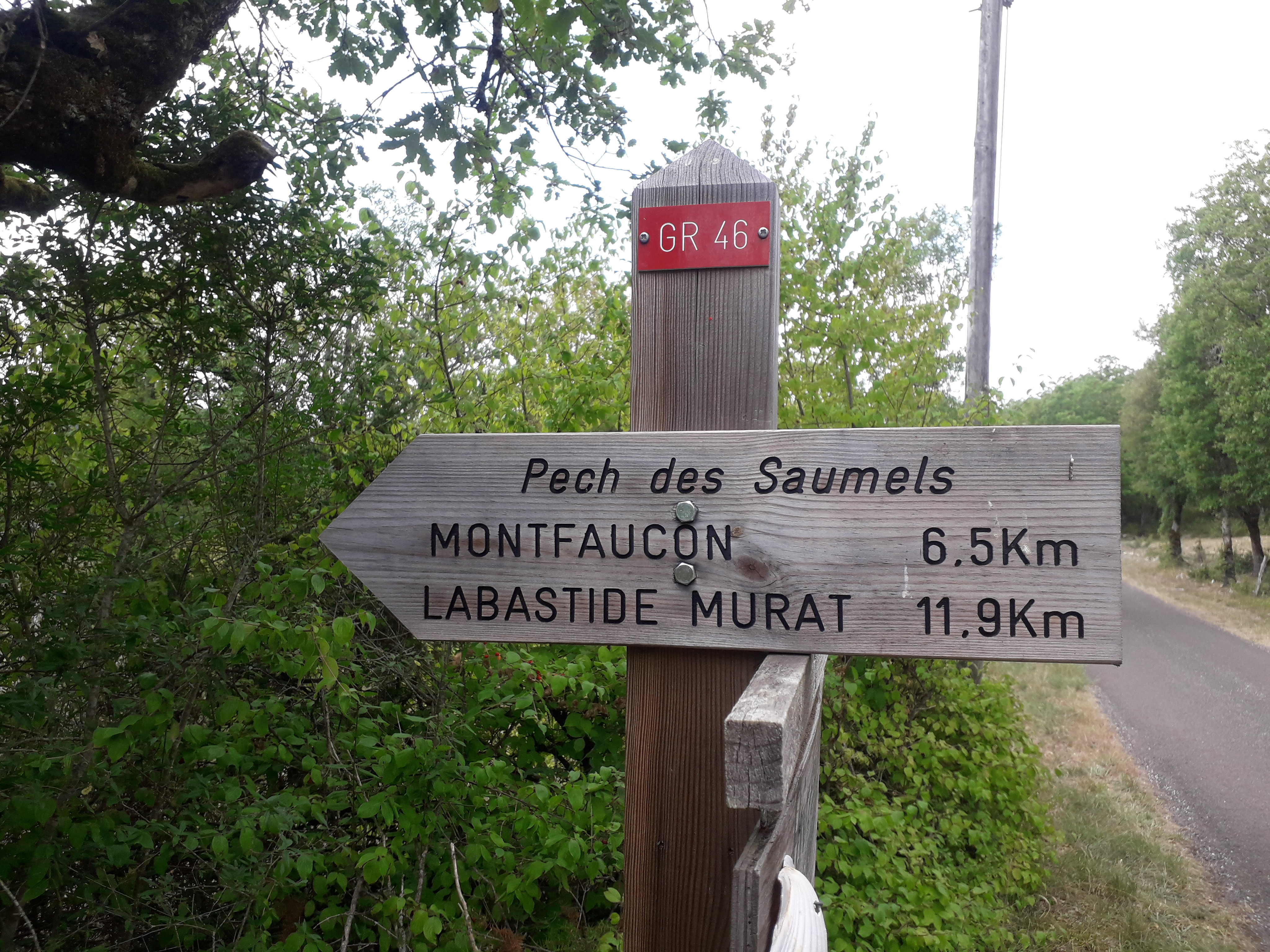
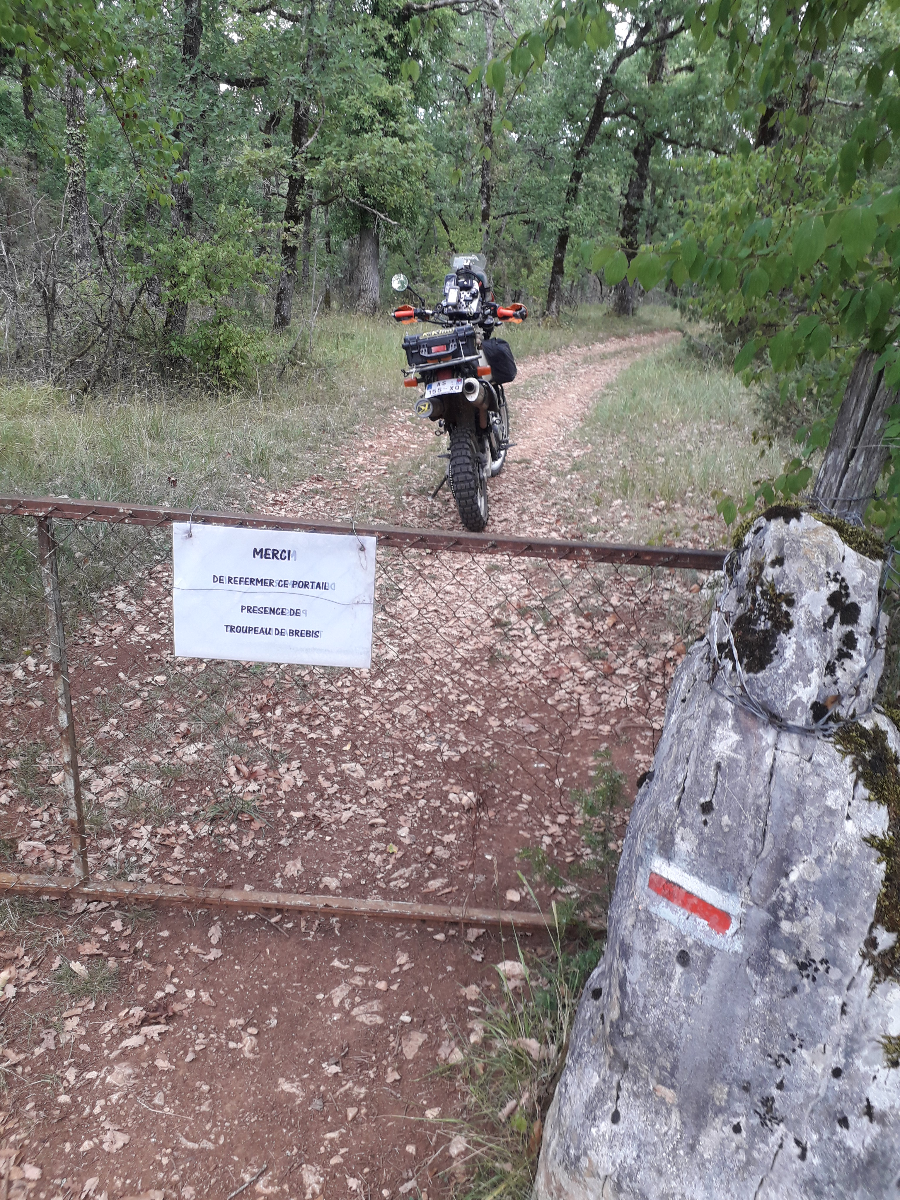
a couple of pics from France somewhere between Le Harve and Grenoble
DSCN1964.JPG
DSCN1964.JPG (110.78 KiB) Viewed 1860 times
DSCN1973.JPG
DSCN1973.JPG (200.25 KiB) Viewed 1860 times
Onenoodles
Posts: 79
Joined: Sun Mar 28, 2021 6:37 pm
Location: Worcester
Has thanked: 1 time
Been thanked: 53 times

Re: Possible week in France and ...

Post by Onenoodles »

Hi Bikenav ... thanks very much for the reply and advice and you have made very good points.

I need to brush up on the GPS stuff really and get sorted, I use OS maps in the UK for hiking and some off road trails in Wales with the bike and I am ok with that, can see the trails first and plot my route ok.

But when I look at these downloads for GPX files off the TET site then Ijust seem to see squiggly lines with no detail ... `I am obviously doing something wrong and just need to work out what? :lol:

Those pics are the sort of stuff I prefer, love forest tracks ... I can do some tricky stuff and have a few times but just don't want it too often :D

Thanks again
PHILinFRANCE
Posts: 6065
Joined: Wed Aug 24, 2011 5:35 am
Has thanked: 3467 times
Been thanked: 1823 times

Re: Possible week in France and ...

Post by PHILinFRANCE »

https://www.gr-infos.com/gr-en.htm

all marked with a red and white stripe, some have been only footpaths for a long time but most are passable with a 2CV
User avatar
Godspeed
Posts: 1904
Joined: Mon Nov 04, 2013 12:35 pm
Has thanked: 2585 times
Been thanked: 2202 times

Re: Possible week in France and ...

Post by Godspeed »

That’s amazing Phil!
Any idea how you save the interactive map to your Google maps?
The Meandering Moustache

Going Big and Riding Small

Honda PCX125 (sports tourer)
Honda Innova ANF125 (Adventure bike)
Cornishman
Posts: 217
Joined: Sun Aug 29, 2021 11:48 am
Location: France
Has thanked: 65 times
Been thanked: 102 times

Re: Possible week in France and ...

Post by Cornishman »

It also depends when you plan on travelling. Most of the bumpy bits in France are in mid winter which means cold, snow and very few open campsites.
When used properly the GPX tracks are viewed in detail on whatever map you choose. The further you zoom in the better the detail. When out and about I use GPS often using pre planned routes loaded on my Garmin. These photos taken just now show how using a satnav doesn’t mean that maps become obsolete, I always start with maps and they are always close to hand.
A4E78F0C-9D7F-4DB9-9F5F-E0C88F526375.jpeg
A4E78F0C-9D7F-4DB9-9F5F-E0C88F526375.jpeg (223.36 KiB) Viewed 1808 times
34457E0F-F9C9-4F00-876A-2E125944E778.jpeg
34457E0F-F9C9-4F00-876A-2E125944E778.jpeg (151.49 KiB) Viewed 1808 times


The equivalent to Ordnance Survey in France are the IGN maps, I always have them in my phone. An additional advantage of the IGN maps is that you can use them to see cadastral plans which are property boundaries. A huge number of tracks pass between these boundaries showing that they are not privately owned and are free to use.

https://www.geoportail.gouv.fr/carte

C15DA900-9C39-4B95-8556-EA82006B341A.jpeg
C15DA900-9C39-4B95-8556-EA82006B341A.jpeg (104.83 KiB) Viewed 1808 times
Last edited by Cornishman on Thu Feb 03, 2022 8:52 am, edited 1 time in total.
Cornishman
Posts: 217
Joined: Sun Aug 29, 2021 11:48 am
Location: France
Has thanked: 65 times
Been thanked: 102 times

Re: Possible week in France and ...

Post by Cornishman »

E5ED2F14-1F11-41C0-AD13-4FB3555E6770.jpeg
E5ED2F14-1F11-41C0-AD13-4FB3555E6770.jpeg (226.4 KiB) Viewed 1805 times
A27D91F8-7AEF-4DEB-8CBE-0A40AB854161.png
A27D91F8-7AEF-4DEB-8CBE-0A40AB854161.png (102.75 KiB) Viewed 1805 times
Here the chemin/track is shown by dotted lines.
6CCE24A0-2F69-47F7-BC42-8F04FF32A566.png
6CCE24A0-2F69-47F7-BC42-8F04FF32A566.png (134.01 KiB) Viewed 1805 times
With the cadastral view you can see the property boundaries which the track passes between.
PHILinFRANCE
Posts: 6065
Joined: Wed Aug 24, 2011 5:35 am
Has thanked: 3467 times
Been thanked: 1823 times

Re: Possible week in France and ...

Post by PHILinFRANCE »

Godspeed wrote: Thu Feb 03, 2022 7:34 am That’s amazing Phil!
Any idea how you save the interactive map to your Google maps?
Sorry Chris , no , but what i do is scroll down from the first map choose a GR from the massive list find the start point usually a town / village and just follow the red and white flashes. They are very clearly marked and repainted often.

Only thing i will stress to ALL is respect every sign because certain sections have been laid over to walking only , very rarely more than a few kms , i just bypass these sections by road and pick the GR back up later , also its not all off road and generally each section heads from village to town to village as they where originally coach roads .....ish

Again please remember to respect my adopted country and you'll have a fantastic time

Image20190818_140729 by Philip Parkinson, on Flickr

Image20190818_141954 by Philip Parkinson, on Flickr

Image20190818_151919 by Philip Parkinson, on Flickr

Image20190224_152423 by Philip Parkinson, on Flickr
bikenav
Posts: 1277
Joined: Mon Jan 28, 2013 11:46 pm
Location: Llanelli
Has thanked: 1187 times
Been thanked: 761 times

Re: Possible week in France and ...

Post by bikenav »

Thanks PIF how will we know the limitations ie walking only, I also saw a sign marked equestrian what is the story with that, passed many of these over the years and been tempted but never actually followed one occasionally ridden a trail where they have joined and left but always considered them the hikers domain, the uneducated eh, think there is a similar network in Spain too. The Geoportal site am I right in thinking that is not a route creator just a point creator? The paper IGN series I have experience of, but is it free to download, can it be used as a GPS navigator plateform, phone or GPS unit or is it a view only type resource? I have a GPX file for some of the GR's if anyone require's it (Mr Speed?) this thread is becoming inlightening. Mr Noodles in the meantime as someone who has evolved their navigation probably along a similar path that you are exploring look up talkytoaster not tried it myself but may be of help at a cost, or alternatively as a free substitute for OS maps outside of the UK look up Open Source Maps OSM . As we have kinda hijacked your thread please throw in any more queries I am sure we will all help to try and skin your cat one way or another, Youtube will also prove helpfull if you feel the need.
Onenoodles
Posts: 79
Joined: Sun Mar 28, 2021 6:37 pm
Location: Worcester
Has thanked: 1 time
Been thanked: 53 times

Re: Possible week in France and ...

Post by Onenoodles »

Well ... some good stuff coming out here, no problem for me anyone chipping in, its not 'high jacking' :D its great info.

I will digest it all and sort something out, sure it will be all good.

Thanks again everyone!
Post Reply

Return to “TRAVEL”